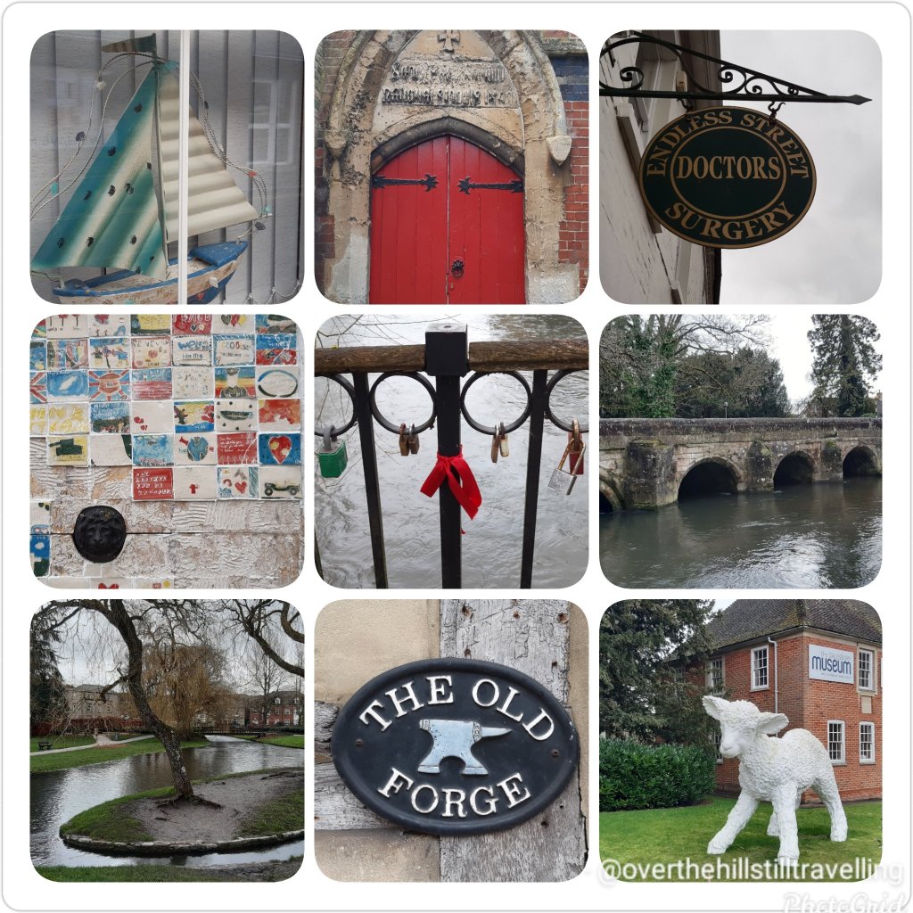
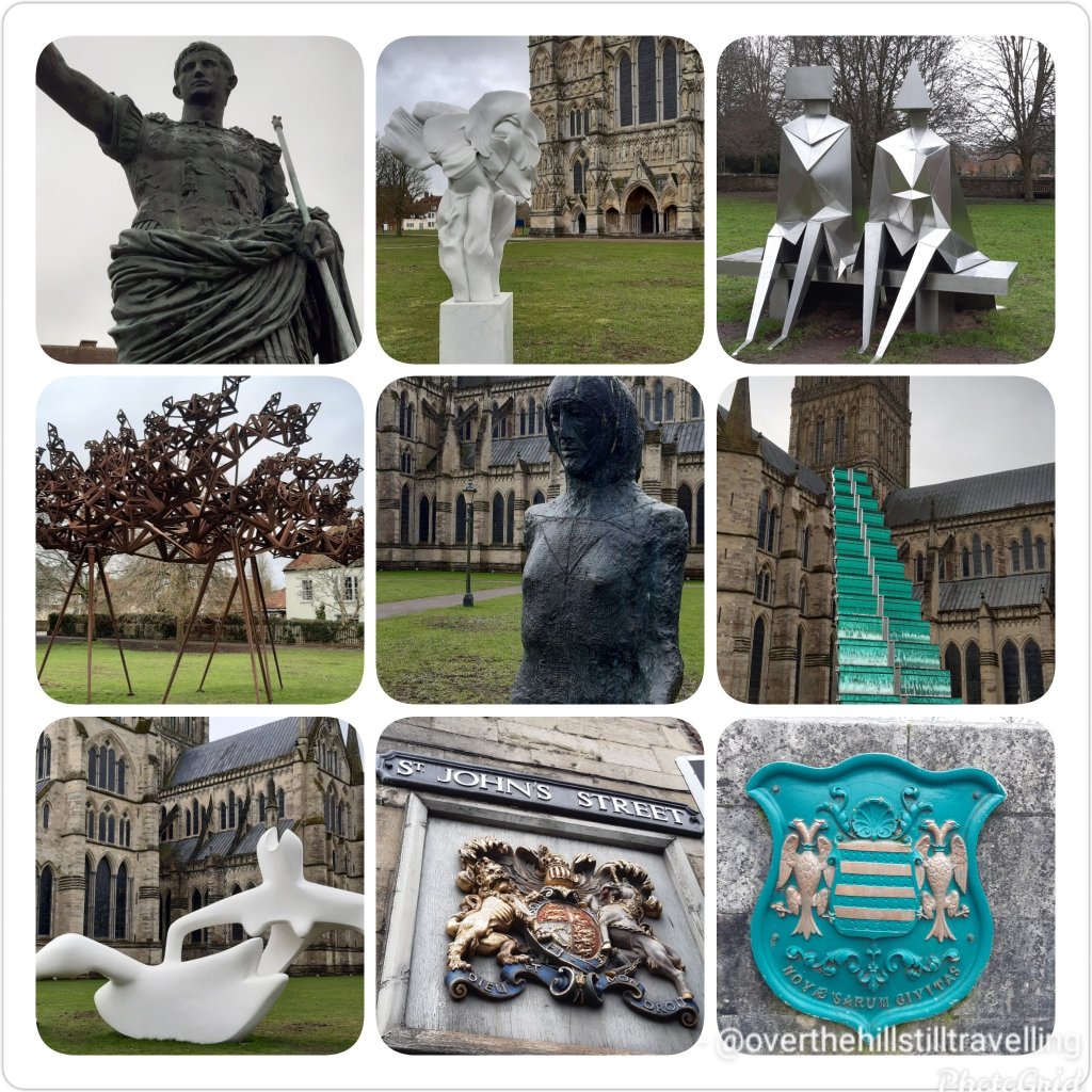
In the real world, on 22nd of February I was traipsing through the meadows and fields of Salisbury, marginally warmer I’m sure, and a heck of a lot easier 😁😁
With the Himalayas towering on either side of the trail, I trudged on and I say trudged because as you may well imagine fatigue, high altitude, low oxygen level and the constantly changing terrain was having an impact but as you may also imagine the desire to climb Everest was even greater and gave me the impetus to carry on.
The terrain morphed from tundra with low level shrubs to rocks and boulders. It was rugged, remote and massive. Rounding the bend at Dughla, a small hamlet and resting point, I was confronted by a pile of rising rubble where high up on the hill at 16,100ft (4,900m) is the terminus of the Khumbu Glacier, the highest glacier in the world. To the right I could see the glacial meltwater as it was making its way down the hill into the Lobujya River flowing southward as the Imja River and into the Dhudh Kosi.
The next hour’s climb was a steep 656ft (200m) trek to Chukpi Lhara. Set atop a large plateau, Chukpi Lhara is Everest’s memorial ground. Monuments made of stone or cement, some covered in prayer flags were built to honour climbers and Sherpas who lost their lives on Everest. It was a sobering and reflective moment.
Located at the foot of the Khumbu Glacier to the east and the soaring peak of Mount Lobuche East to the west sits the seasonally busy village of Lobuche. The village is the second-last stop for overnight lodging before base camp. Mount Lobuche has two peaks and is differentiated by calling it East and West. Permits are required to climb the mountain with East (20,075ft/6,119m) being classed as a trekking peak, whereas West (20,160ft/6,145m) being classed as an expedition peak. The two peaks are connected by a long and deeply notched ridge with sheer drops on either side making the West peak inaccessible from the East but it can be climbed via the southern shoulder.
I didn’t stop in Lobuche, I pressed on to Gorak Shep the absolutely last place to stay in a lodging. The village was buzzing with trekkers and climbers either coming or going. At an elevation of 16,942ft (5,164m), Gorak Shep was located at the base of Mount Pumo Ri on the edge of a frozen lakebed covered with sand with Khumbu Glacier to the east and Changri Shar Glacier to the west.
The village was completely barren and devoid of vegetation but the peaks were ever-present from every angle. The summit of Kala Patthar on the south ridge of Pumo Ri was a major landmark for any trekker who wanted a clear view of Everest and Nuptse’s peaks. Because of Everest’s structure view of its summit from base camp is blocked by Nuptse. Climbing Kala Patthar was another great way to acclimatise. With an elevation gain of 1,270ft (390m) it was a short-two hour return trip. After a hearty lunch of curry potato and paratha bread for dipping, I was ready for the last trek of the day.
And here I thought I did good climbing halfway up Mt. Snowdon!!! And no, I still can’t do a decent selfie 🤪🤪
November 2017, Mt. Snowdon. My hair was still pink after my Camino in September 🤪🤪🤫
It all sounds absolutely amazing, and the curry potato sounds yummy, but as for the rest of it, I get tired just reading about it and once again I’m ever so glad this is not something I ever have to do 🥶🥶🥶😰😰 it just sounds exhausting.
Reading through this information, I’m left thinking that some people need their heads read!! I know I push myself and I’ve done some crazy shit when on my long-distance walks, but I would not want to do any of this. Thank the lord it’s a virtual climb and I don’t ACTUALLY have to do this 😁😁😁😄 instead I was whizzing around Salisbury
Exploring Salisbury – far more my style ☺
Starting out with an easy hike, I nearly missed the iconic yellow and red sign against a huge boulder simply stating “Way to Everest B.C.” with a big red arrow beneath the words pointing towards base camp. At least I was certain I was on the right path.
After what felt like hours of trekking, the treacherous Khumbu Icefall loomed into view spilling its way down the valley between Everest and Nuptse. Khumbu Icefall sits at the head of Khumbu Glacier, a constantly moving sheet of compacted ice. As the glacier makes its way down the valley it fractures, creating deep crevasses that are always in motion and large towers of ice called seracs that are known to suddenly collapse. Making the final ascent I arrived at the cairn adorned in prayer flags with its rudimentary sign signalling that I have arrived at Everest Base Camp (17,477ft/5,327m). It was located on a scree-covered section (loose broken stones) at the foot of Khumbu Icefall. I settled into one of the yellow tents and mentally prepared for the high altitude acclimatisation process I would begin to endure.
As sea-level dwellers our bodies are not designed to live at high altitude but we are certainly capable of adapting to it through appropriate acclimatisation. The higher we go, our bodies go through physiological changes by producing more red blood cells in order to carry more oxygen to our muscles and organs whilst combating the thinner air.
The acclimatisation process on Everest is lengthy taking up to a month and done by exposing the body to higher and higher altitude then descending to sleep, recover and overcome any signs of acute mountain sickness due to sudden changes in altitude.
High altitude sickness can affect any person regardless of fitness or age. Ignored or left untreated altitude sickness can have serious consequences including fatality by developing either into cerebral oedema or pulmonary oedema which is fluid build-up in the brain or lungs. Some of the immediate ways to treat altitude sickness is by taking specific medication, supplemental oxygen and/or descending.
During that month I climbed and returned to base camp three times with each climb going higher. It looked something like this: 1. Base camp to icefall, return to base camp. Have a day of rest. 2. Base camp across icefall to Camp 1 and stay; then Camp 2 return to Camp 1 for sleep; then Lohtse Face return to Camp 2 for sleep; and descend back to base camp. Have four days of rest. 3. Climb to Camp 1 and stay; then Camp 2 and rest the next day; then Camp 3 return to sleep at Camp 2; and descend back to base camp. Have five days of rest and wait for the right weather to summit.
The anticipation was over and the much awaited good-weather window presented itself for the final part of the expedition: Summitting Everest.
Starting in the wee hours of the morning, geared up and harness on I negotiated my way through the camp under the light of my headlamp to Crampon Point and attached my crampons to my boots.
Staring out at Khumbu Icefall with a good dose of mixed emotions I began the perilous yet now more familiar climb across. Crevasses were crossed on horizontal ladders and towering ice blocks on vertical ones. Some crevasses were so wide that more than one ladder had to be tied together to bridge the gap. For safety I was clipped into fixed lines. If I was to lose my footing on the ladders and fall the fixed lines would help break my fall. Climbs in some areas fluctuated between 20 to 60 degree angles but there was no time to dwell as the ongoing shifting and settling of the glacier and icefall was a constant reminder how unsafe the area was and moving quickly was necessary.
Several hours passed crossing the icefall till I made it to a large flat expanse of snow with more ladders to climb all the way to Camp 1. Situated at 19,390ft (5,910m), Camp 1 was in the middle of the Western Cwm (Cwm is Welsh for valley), a broad and flat glacial valley. From here I could see the Pumo Ri Mountain to the west and Lhotse Face straight up the valley. I then climbed on to Camp 2 about 1.74mi (2.8km) further up from Camp 1. Located at the base of a gully on scree, Camp 2 was well provisioned and is often considered as Advanced Base Camp. I stopped for a day of rest.
Early next morning I began making my way across the Western Cwm to the base of Lhotse Face where I had to cross a short ladder over a bergschrund (a deep crevasse where the steep slope meets the glacier). Lhotse Face is a 3,690ft (1,125m) glacial wall of blue ice. Sections of Lhotse Face average 40 degrees incline thereby needing to kick my crampon points into the ice to secure my footing. Throughout this climb I was clipped into a fixed line which was attached to the face with ice screws and anchors. I could feel the altitude change, my breathing labouring as I slowly and steadily climbed my way into Camp 3. I was now at 24,015ft (7,320m) gaining an elevation of 6,538ft (1,993m) from base camp. There were several camping spots here, essentially wherever one could find a flat spot to pitch a tent. I remained fixed to my safety line. The sun was up bestowing me with glorious views of the valley below, the peak of Pumo Ri and the others beyond.
Quite honestly, that all just sounds like a lot of hard work – so for me, its a no thanks. I’ll stick with my virtual journey and leave this to someone else. Seriously?? Why would anyone want to do this??
If seems there are still some mountains to be climbed. In a way its quite awesome to learn that not all mountains have been conquered, especially as it is a sacred mountain…some things should just be left alone…onwards and in reality when I reached stage 3 in was exploring Salisbury
Leaving Namche Bazaar, the trail was wide and level following the curves of the Khumbu Yui Lha mountain. The mountain is 18,900ft (5,761m) above sea level and considered sacred by the Sherpa people. With the exception of one unsuccessful attempt in the 1980s, the mountain has never been climbed.
As beautiful as it is, it just looks cold..
Winding my way up the trail, I could feel the climb in my legs as my muscles strained on sections of steep, stone steps then levelling out and just around the next bend it’d be another round of steep steps and on and on it went. Occasionally, I’d be rewarded with tiny peeks of Everest in the distance.
Suddenly, my trail began its descent to the valley floor and if I thought my muscles strained on the ascent, I now felt the strain on my knees during the descent. Reaching the village of Phungi Thenga, I traversed Dhudh Kosi river again and just as I made it into a gorge the trail took on another brutal ascent all the way to Tengboche. The highlight in the village is the Tengboche Monastery, a Tibetan Buddhist monastery for the Sherpa community. First built in 1916, the monastery has been destroyed and rebuilt a few times. Home to 60 monks, the prayer room is a kaleidoscope of colour with murals and paintings adorning the walls. A nunnery is a short trek away in Deboche.
Tengboche is beautifully located with its panoramic views of several peaks but the most outstanding was Ama Dablam and its imposing 22,349ft (6,812m) peak. Flanked by long ridges and a hanging glacier, it was first climbed in 1961 and it is the third most popular Himalayan peak for climbing.
The constant up and down trekking seemed a little self-defeating until I realised that since Lukla, I was an extra 3,280ft (1,000m) above sea level. I couldn’t ponder that for long as down into the valley I went again to cross Imja Khola river, a tributary of Dhudh Kosi.
Once I crossed the river, I left the woodland behind. The trail from here was in the open, no more trees in the way of my view presenting me with the enormity of this place. Up and down went the trail, yet progressively gaining elevation. The air had changed. A little thinner, a little colder, no trees to provide shelter from the wind.
Eventually I reached the tiny village of Phiroche. It is located above the Tsola River at an altitude of 14,340ft (4,371m). It is a major stopping point for acclimatisation and also an evacuation point. The village has a hospital that runs during the climbing seasons and is operated by the Himalayan Rescue Association with Nepalis staff and volunteer doctors from the US, Europe, Canada and Australia.
Rather than sitting in a lodge, I dug out my gloves and beanie and very slowly over a period of about two hours, I hiked up to Nangkartshang peak (also referred to as the Dingboche Viewpoint) with an altitude of 16,676ft (5,083m). I was wonderfully rewarded at the top with a glorious view of several peaks such as Ama Dablam, Imja Tse, Tobuche and Lobuche and further afield even higher peaks Cho Oyu, Makalu, Lhotse and of course Everest.
As dusk was closing in I retired to my lodge for dinner. Looking for a warm and comforting dish, I settled on a hot noodle soup with pieces of meat and vegetables called Thukpa, accompanied by hot momos, steam filled dumplings.
Amazing to learn about all if this. Certainly one of the highlights for me following these virtual challenges is the postcards, I really do find it ever so interesting.
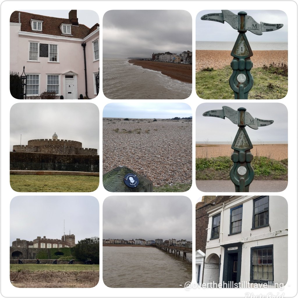
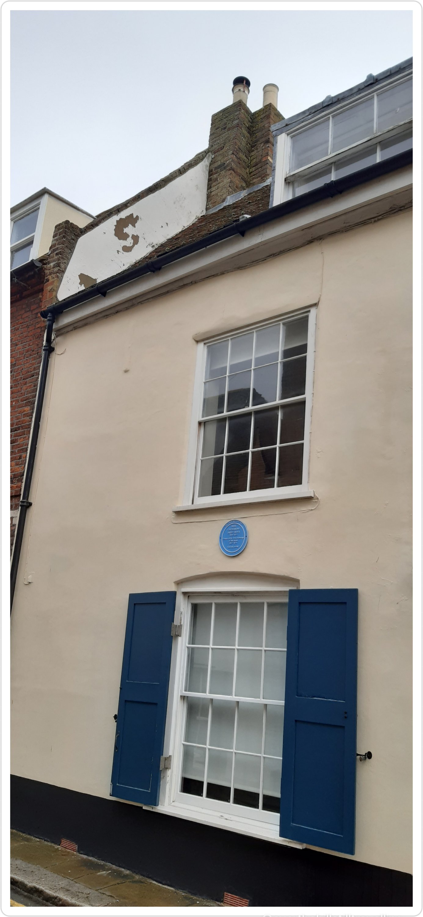
I reached stage 2 while I was in Deal for my Covid-19 innoculation and the weather wasn’t much better by all accounts, although they had blue skies, whereas mine was grey
Walking in Deal
Leaving Hillary Bridge behind at 9,514ft (2,900m) it was time for the next gripping ascent. Travelling uphill on single-lane switchbacks demanded patience, slowly shuffling along putting one step in front of the other, often needing to pull aside to let the steady stream of traffic pass me by. Mules, trekkers, porters and yaks were a common sight, breaking my already slow momentum. As I was gaining elevation, I could feel the change in the air, a shortness of breath, clearly indicating the change in altitude. I’d say more garlic soup was on the horizon.
Two hours later I arrived in Namche Bazaar, the largest village in the region. Namche was located on a plateau, rising up the hillside at 11,285ft (3,440m). On either side of the village were the 19,800ft+ (6,000m+) peaks of Kongde Ri to the west and Thamserku to the east.
From single-storey to triple-storey buildings, a plethora of teahouses and lodges are readily available to service visitors and trekkers. Anyone who was up for a pint of Guinness or a shot of Jameson or Teeling Irish whiskey would find it in the centre of town at the remotest Irish Pub in the world.
Namche is a trading centre, altitude acclimatization stop, gateway to the upper Himalayan region and the final stop to purchase any gear needed for the upcoming trek to Everest.
Resting here overnight and taking the time to acclimatize, I stopped at a teahouse to enjoy the national dish of Dal Bhat Tarkari, a lentil soup with steamed rice, accompanied by seasonal vegetables and curried meat. It is a staple meal of the Sherpa people eaten once or twice a day as a perfect combination of protein and carbs for their physical workouts at high altitude.
Just slightly out of town up a hill is the Sagarmatha National Park Museum with a statue of Tenzing Norgay on the grounds. A worthy visit not just for the museum but also the amazing views of the surrounding peaks.
I spent a full day acclimatising with a nearby hike to Khumjung at an ascent of about 2,000ft (600m). Khumjung is a village known for the Edmund Hillary School which when built in 1961 only had one classroom but today teaches children up to grade 10. Then onto Khumjung Monastery to check-out the mysterious yeti scalp. The yeti is steeped in Himalayan folklore as a large monster which in western culture is known as the Abominable Snowman.
Before descending back to Namche, I grabbed a pastry and hot drink from the closest bakery and whilst standing outside absorbing the mountainous vista I watched the Sherpa women harvest the potato fields, a staple crop and one of the few that can be grown at such high altitude.
One more night of rest in Namche. The long, slow, steady climb awaits.
Crikey, reading all that makes me glad I’m not really there 🤪🤪🤪 even though it would be quite cool to visit the remotest Irish Pub in the world 🍀🥳💚💚
I finally found a bit of space to start reading up on the Mt. Everest virtual challenge which I completed last month, and although I had decided to not post any further posts about the various challenges I’m following, this was so very interesting that I changed my mind and so here we go….I hope you enjoy reading more about Everest and what the climbers who actually go there experience. So often we read or hear about climbers and teams of people who climb Mt Everest but we seldom read about the finer details. So this has been really interesting.
I actually started the challenge in Ramsgate on the 10th February on the tail-end of the ‘beast from the east’ snow storm. So this is a bit behind the actual times 😉 But since it’s not real anyway, it doesn’t really matter…anyway, I hope you enjoy reading these posts…
Where I actually was….pretty realistic really
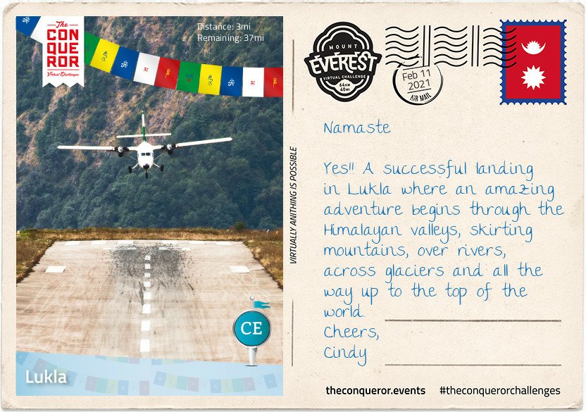
Flying into Kathmandu is a walk in the park when compared to Lukla. Dubbed as the most dangerous airport in the world, Lukla’s runway is a mere 1,729ft (527m) long, with mountainous terrain to the north and a steeply angled drop to the south. It is built on a 12% uphill gradient to help planes slow down. There are no go-around procedures if the planes miss their approach, as such only highly experienced pilots with short-takeoff-and-landing missions under their belt, experience in Nepal and ten flights in Lukla with a certified instructor, are permitted to land at the airport. In a nutshell if climbing Everest doesn’t cause prickles on the back of your neck, then a high intensity landing in Lukla certainly should.
Where I wasn’t really 😁😁 Stage 1
In 2008, Lukla airport was renamed Tenzing-Hillary Airport in honour of Sir Edmund Hillary and Sherpa Tenzing Norgay, the first climbers to reach the summit of Everest. Hillary was instrumental in the construction of the airfield in Lukla, building an unsurfaced airstrip on a mountain shelf in 1964. It took 37 years to finally asphalt the runway.
Home to 1200 people, the village sits at 9,383ft (2,860m) above sea level, nestled on a small plateau amongst the awe inspiring mountain peaks of the Himalayan Ranges. The nearly 40mi (64km) trek to Mount Everest, skirts steep mountainsides, through deep valleys and over alpine glaciers. The hike travels through small villages and teahouses, past prayer wheels and fluttering prayer flags to the memorial site honouring mountaineers and Sherpas who lost their lives climbing the mountain, continuing to Base Camp and then the final summit climb. Leaving the viewing platform of the Lukla airport, I made my way through the centre of town on a narrow street that was sometimes cobbled and sometimes just compacted soil. Double-storey buildings lined the street filled with shops, teahouses and lodging services.
Shortly after leaving the village I passed through the National Luminary Pasan Lhamu Memorial Gate which was built to honour Pasan Lhamu, the first Sherpa woman to summit Everest in 1993. It is the gateway to the Khumbu Region that encompasses the Sagarmatha National Park and the Nepalese side of Mount Everest.
It was a gradual downhill hike, passing through a forest on narrow paths with the colossal mountainside ever present to my right. I continued on this downward hike, on a trail that wound itself up and down, passing through villages with teahouses until I reached Phakding, a small village that lies in the Dudh Kosi river valley. Here was the first of many suspension bridge crossings. The bridge, about 100ft (30m) above the river, stretched across what seemed to be an old landslide with large boulders and debris settling beside the river. As the bridge swayed and moved beneath my feet, I pondered about those whose fear of heights may find the crossing challenging. This isn’t the tallest suspension bridge on this trek, that is yet to come.
Finally reaching the small village of Benkar with its tin-roofed, brightly painted window frames, four-storey residences/storefronts, I settled into one of the teahouses for a meal. Known to aid with altitude adaptation I had garlic soup with Tibetan flat bread. Between the warmth of the soup and the crusty on the outside, fluffy on the inside bread, I filled my belly and finished with a Tibetan tea. Rested and fed, I resumed my hike crossing another suspension bridge. Soon I reached the entrance to Sagarmatha National Park. A UNESCO listed site since 1976, the 1,148km² park is home to the Sherpa people, rare species like the snow leopard and several mountains including Mount Everest.
After obtaining the necessary permits to enter the park, I walked through the Jorsalle Entrance Gate, a concrete structure with Buddhist artwork on its interior walls to a set of steps that began a steep descent into a gorge, onto Jorsalle village, alongside the thundering Dhudh Kosi river and over two more suspension bridges.
However, what goes down, must come up and it wasn’t long before I engaged my hiking poles to start the steep ascent onto a woodland path until I reached a wide open low lying land beside the river filled with stones and boulders making trekking through it unstable and difficult.
But nothing prepared me for the next suspension bridge. Like all the others, Hillary Bridge was made of galvanized steel cables that’s connected to the grated deck by interlinked wire fence. An old version of the bridge was right beneath this one just hanging, blowing in the wind, no longer in use. At 410ft (125m) above the Dhudh Kosi river, this 459ft (140m) long bridge was exposed to the elements swaying laterally and vertically as the strong wind blew through the valley. It was a heart thumping, adrenaline spiking exercise that on this trek one could do without. I was grateful to reach solid ground.
If I ever entertained even the slightest idea of ACTUALLY doing this ‘walk’, reading about that bridge has pretty much scuppered any possibility 🤣🤣🤣 I don’t have a fear of heights and I’m a bit of an adrenaline junkie, but I have my limits 🤪🤪
So, no go for me thanks, virtual suits me just fine.
I arrived home last night, after a 4.5 hour journey, from a week’s booking in Salisbury. As much as what I really enjoyed exploring the city, and learning more of the history and her green spaces, it was wonderful to be back home.
You cannot underestimate the sheer joy of coming ‘home’ to your own place. It may not be much, but it’s got my stuff in it, and I’m home.
My own duvet…magic
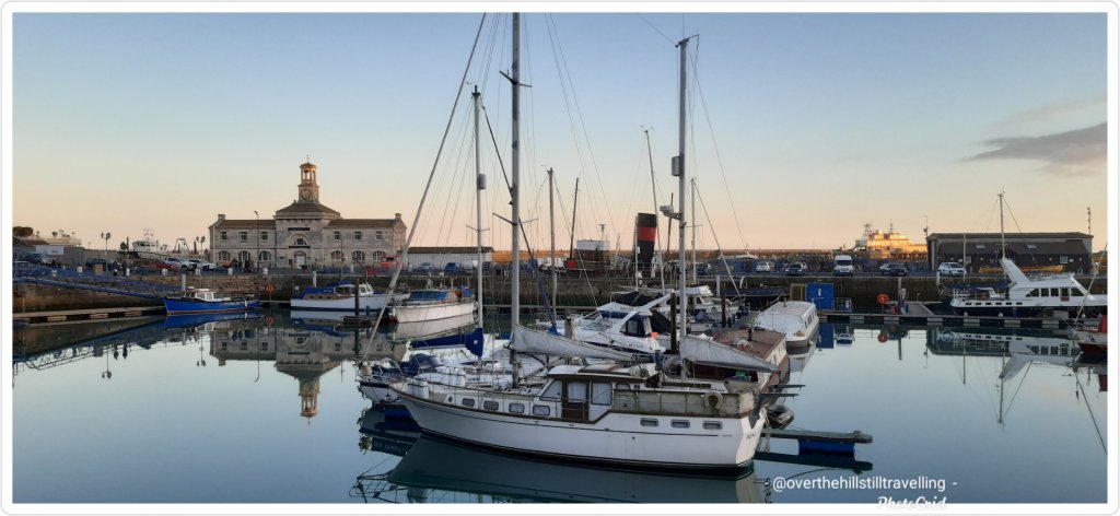
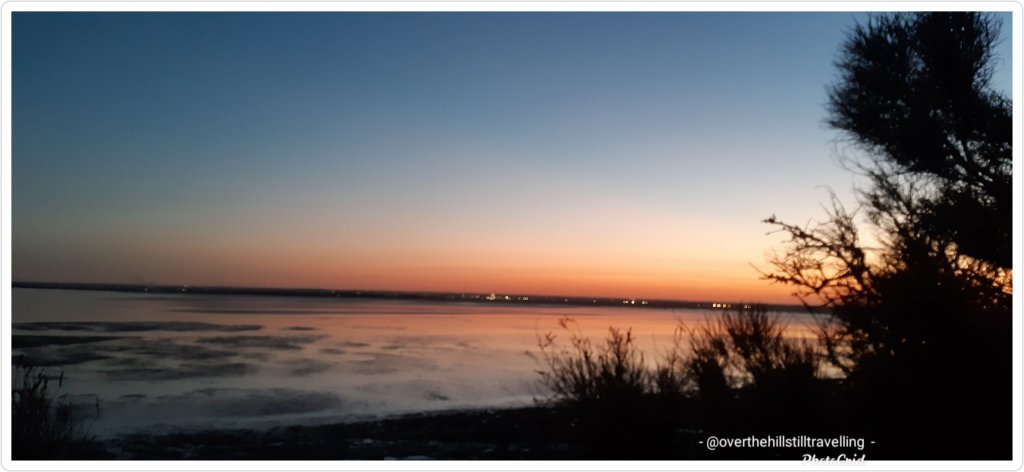
After I’d dropped my bags off, I grabbed my walking poles and immediately set off for a sunset walk to the harbour
Absolutely stunning A Royal harbour Can you see the moon?The sun setting in front of me
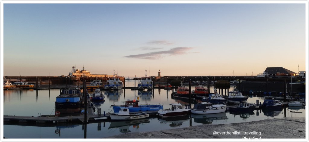
and then along the lower promenade
The snow moon rising behind me
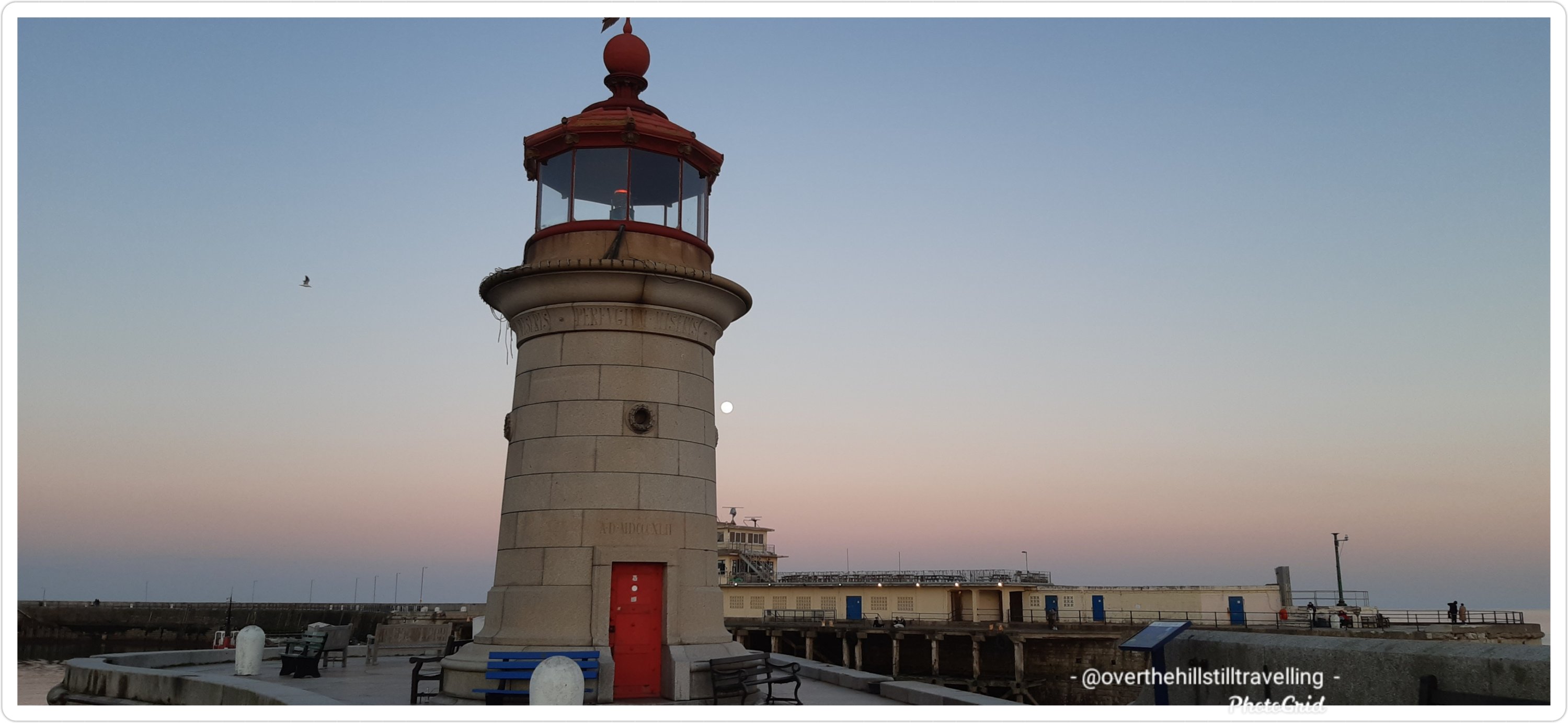
before climbing up to the clifftop and a walk to Pegwell Bay.
View of Pegwell Bay from the bottom of the cliffs From halfway up the path to the top of the cliffs
It was quite dark already by the time I reached the hotel, so I stopped there for a few photos and then walked back along the clifftop.
View from Pegwell Bay hotel A bit of fun with the moon and the hands and molecules sculpture One lone boat still has its Christmas lights on
A magical walk with no pressure to get back within 2 hours, and 9.9 kms added to my 2021 Conqueror virtual challenge.
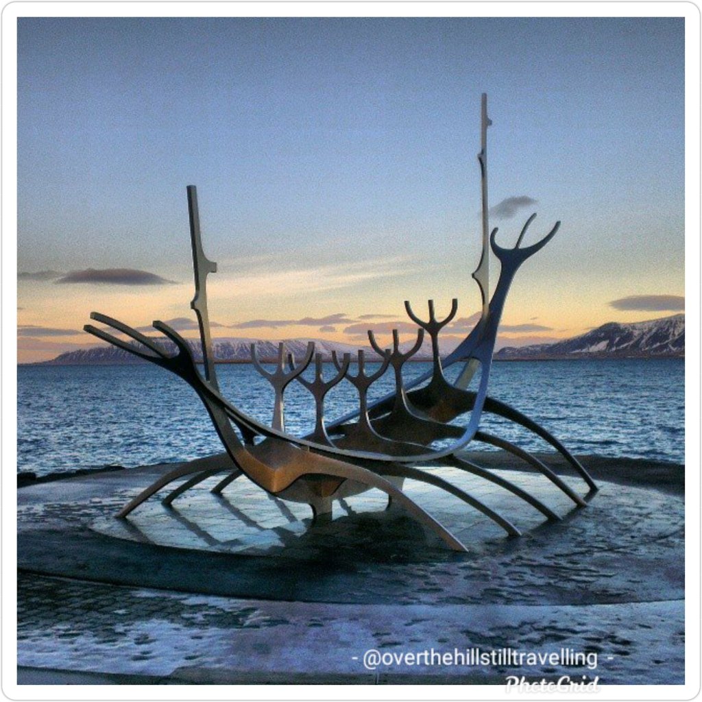
I’m going to start the Ring Road Iceland virtual challenge on Monday 1st March. I’m so looking forward to the postcards, should be amazing. My daughter and I had a fantastic 4 day trip to Iceland in 2014, so I’m really keen to see the information that comes with the postcards.
The Sun Voyager (Icelandic: Sólfar); a sculpture by Jón Gunnar Árnason
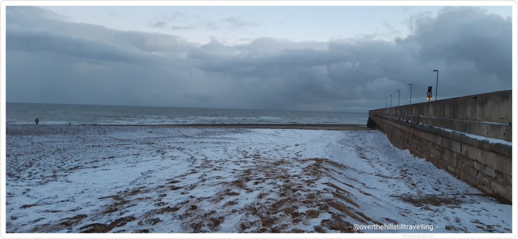
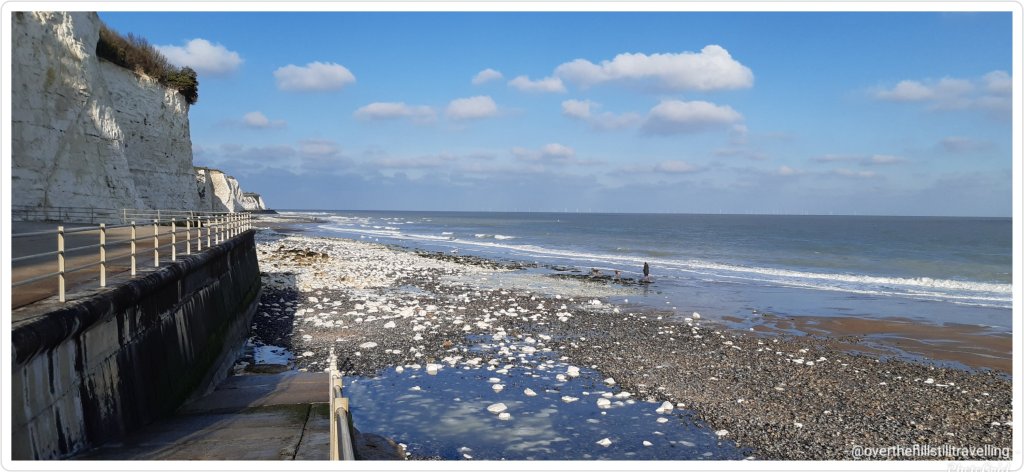
When I got back from my Throwley booking earlier this month, I decided to take a walk along the beach to get some kms in since I’d completed the Alps to Ocean challenge and started climbing Mt. Everest 🥶🥶🥶🗻🗻 (also completed while in Salisbury).
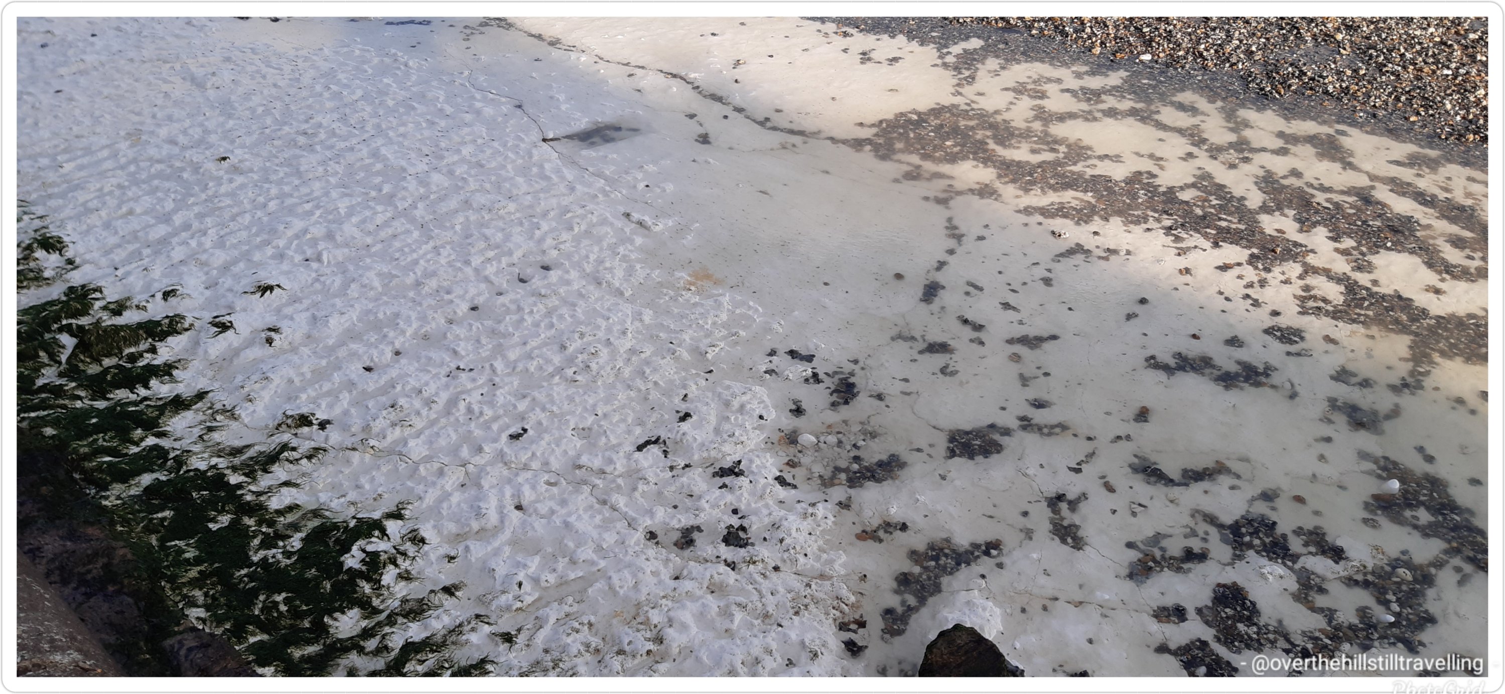
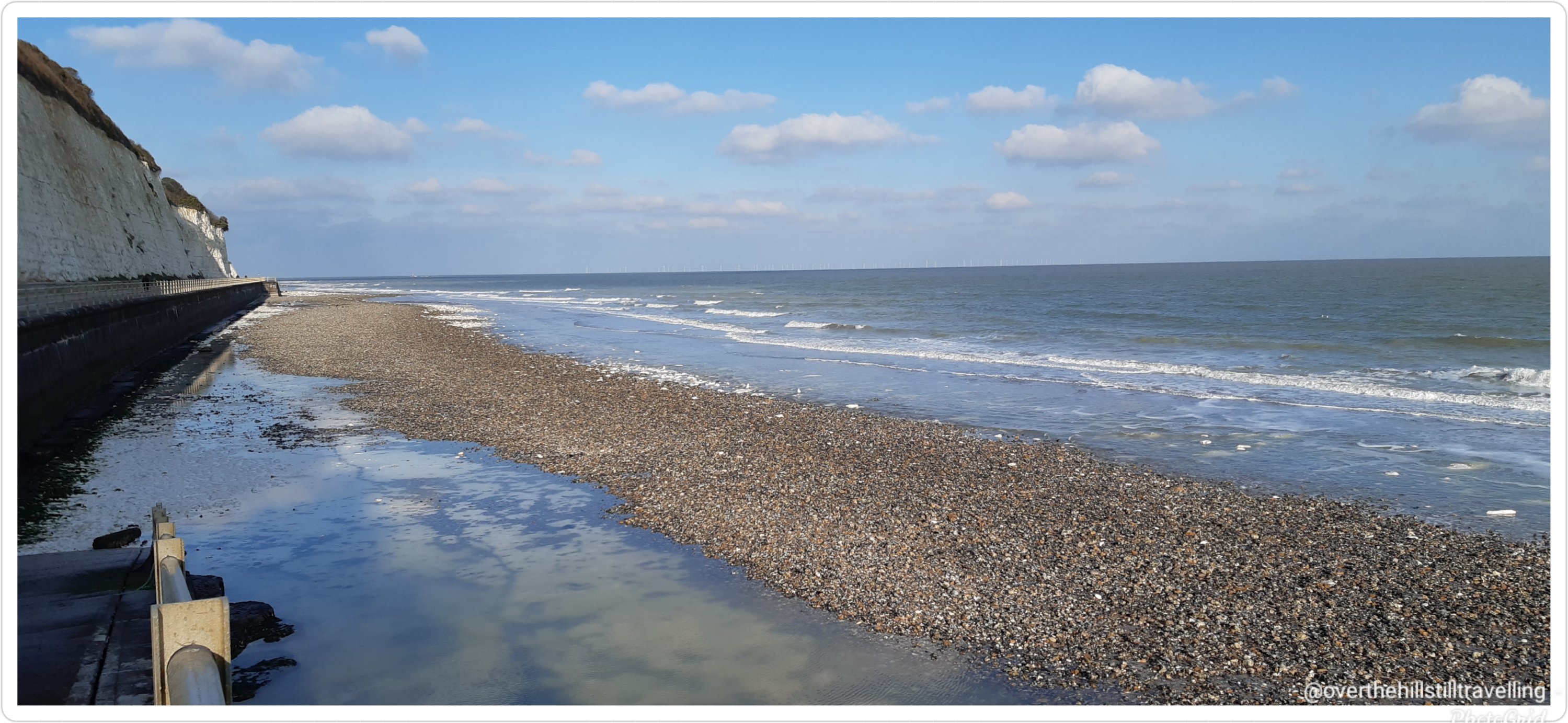
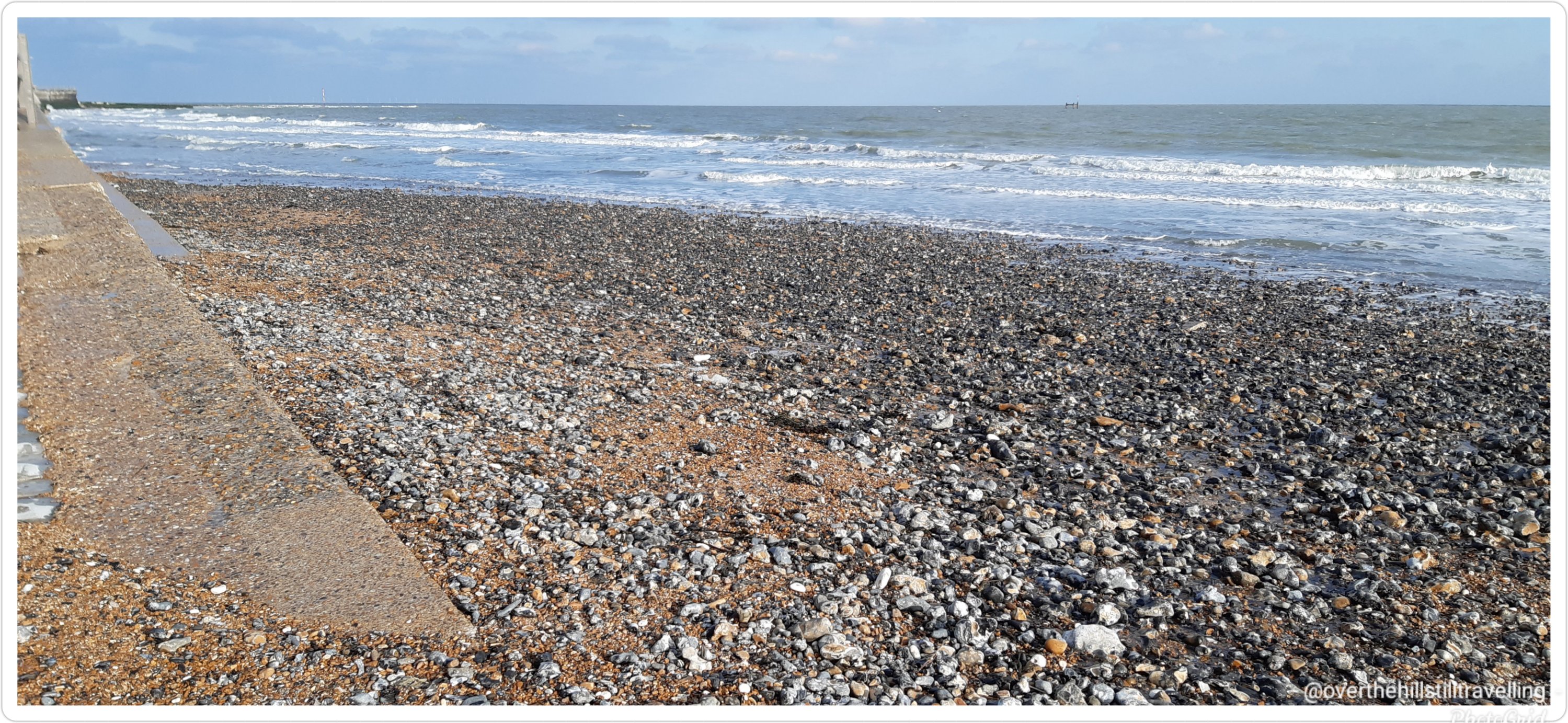
BUT!!! To my horror I found that most of the beach has been stripped away by the storm. As far as the eye can see, used to be beach…its now mostly stones and rocks and the sand has been stripped right down to the chalk bedrock. I genuinely could not believe my eyes. I can see just beneath the waves there’s still some beach, but not sure how far it extends.
The beach where I used to take my grandson to play is now just a rocky morass.
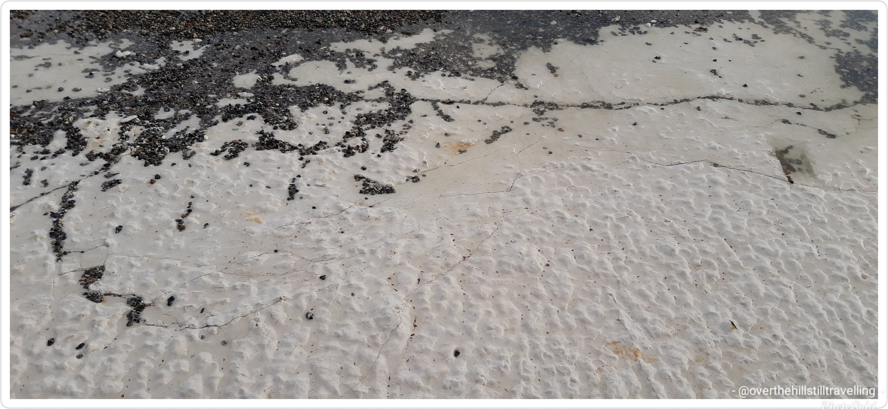
To give you an idea of the power of the sea, this great big chunk of very degraded concrete was washed up and dumped onto the beach almost halfway up towards the Royal Pavilion Quite awesome to see the pure chalk bottom though…just think….this is billions of sea creatures solidified into chalk from millions of years ago.
Unreal, the power of nature. I’m saddened too because it’s one of my favourite places to walk. But a local said the wind and sea will likely blow it all back when the winds blow from another direction. Meanwhile…😔😔😔 no beach walking🚶🏻♀️🚶🏻♀️ for me atm, I’ll have to try catch it when the tide is out.
Meanwhile, I shall have to head southward and visit Pegwell Bay again.
I had to concede defeat today and had my first Covid vaccine jab. I’m not happy about it, but when you start hearing things like “have you had a test recently, or when will you be having your innoculation?” from prospective clients et al, along with talk of vaccine passports, you know the writing is on the wall. We are but a commodity.
So I just said, to hell with it and booked an appointment. So many people are still totally ignorant of Covid and its transmission. Having the vaccine is not going to stop me from inadvertently passing it on to someone else in the event I come into contact with it. Its seems that some folk think it’s a magic wand, and once you have the jab you’re safe. You’re not. You’re just less likely to get really ill, and even then it’s no guarantee. Even the scientists are not wholly in agreement about the efficacy and what it means. Ugh. Anyway, it’s done. I can’t afford to not work.
The process itself was painless in all respects, and the system was smooth and flowed easily. Because of previous negative responses to a flu vaccine, I stayed institu for 25 minutes after the jab, just to make sure I didn’t just keel over and die 🤪🤪 and then I was away…the staff were friendly and well organised and I was impressed with the efficiency of it all. I still, 9 hours later have had no ill-effects. In case you’re wondering, I had the Astra-Zeneca vaccine. 🤔🤔🤔
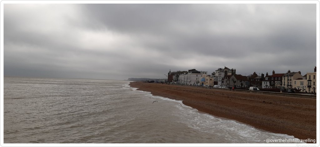
The good thing that came out of it is that I had an unexpected trip to Deal. After the jab, I set off for a walk to Walmer Castle. Its amazing how close the 2 castles are to each other…25 minutes brisk walk. But first I had a most delicious curried vegetable pie from Al’s Bakery on the High Street…totally recommended. If I’d known it would be so yummy, I’d have bought 2.
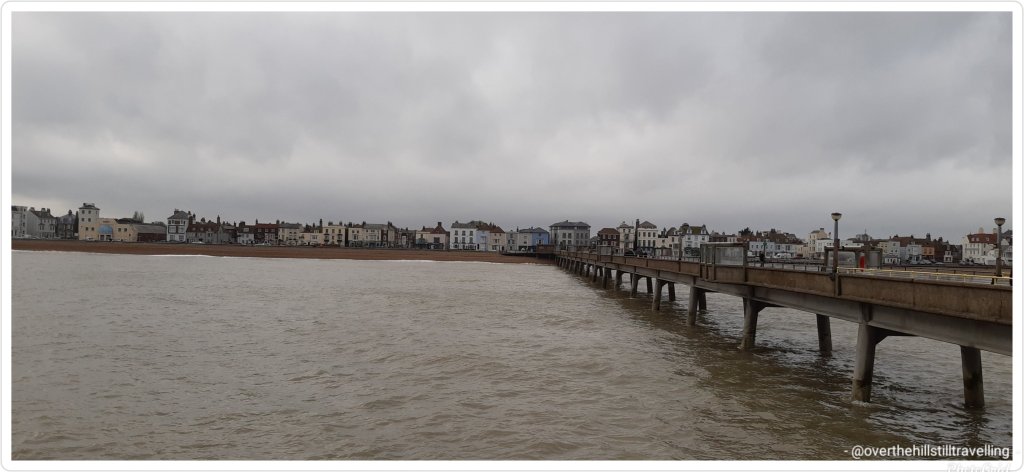
A quick walk along the pier as well, then back on the train…which remarkably, considering the delays caused by the land slip near Folkestone, arrived at Deal and stopped at exactly 14:32 (I was watching the clock) – even a Swiss train would be hard put to match that!! 😉
It’s a very long pier
Oh, and see that arrow pointing to the land in the distance in the next image… that’s the White Cliffs of Dover and last year I walked from Walmer to Dover via the cliffs…awesome walk and really beautiful
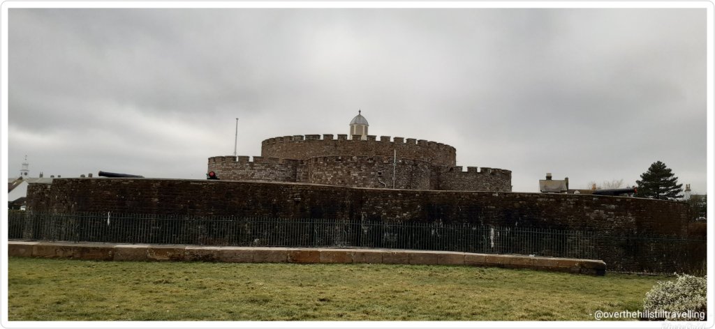
Deal Castle Walmer Castle
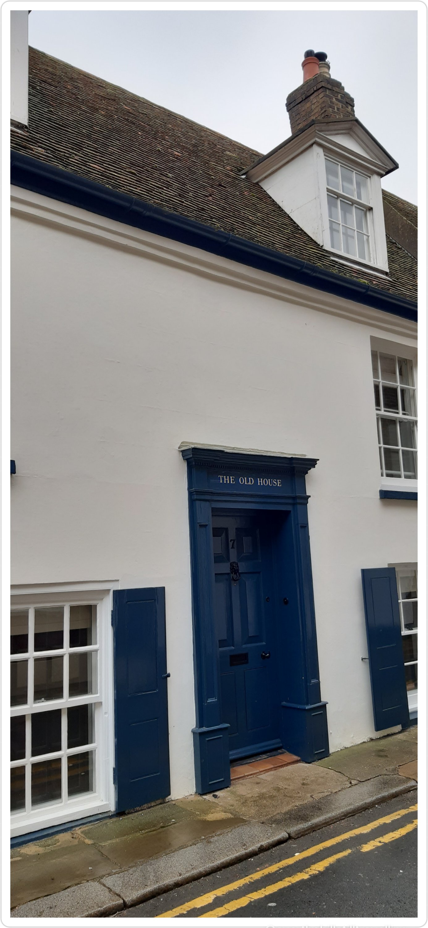
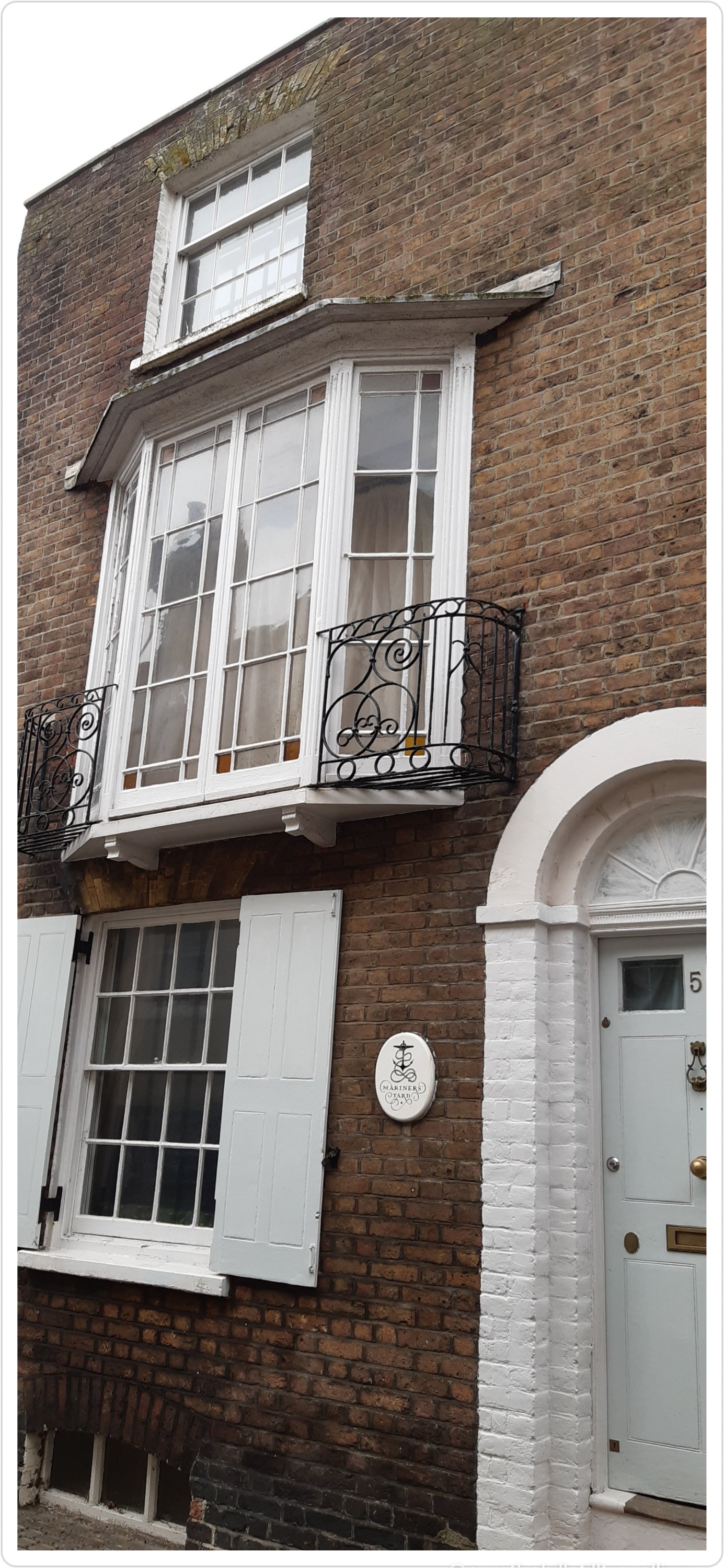
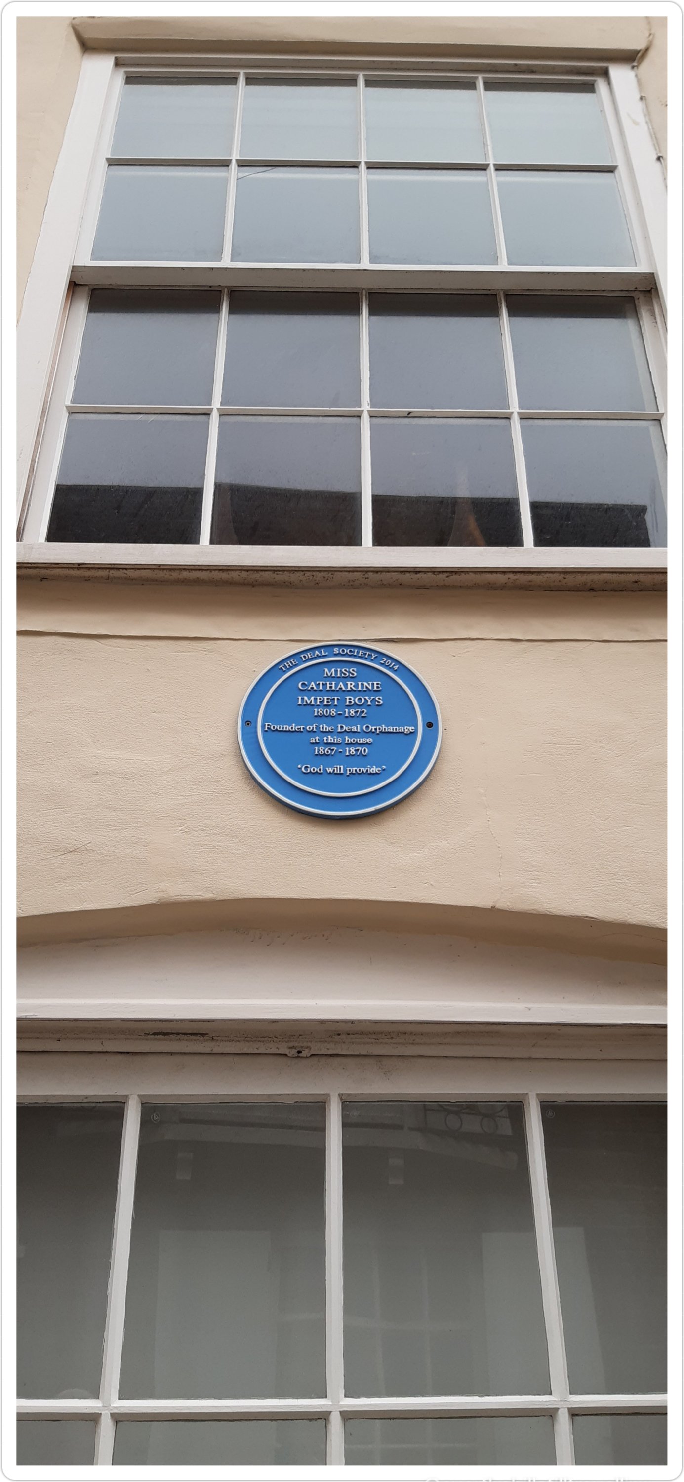
Deal is an incredibly historic town with some amazing old houses
Carter House
Although it was wet, cold and blustery, I really enjoyed my walk and as usual could have just kept going….as soon as lockdown lifts, that’s exactly what I’m going to do…
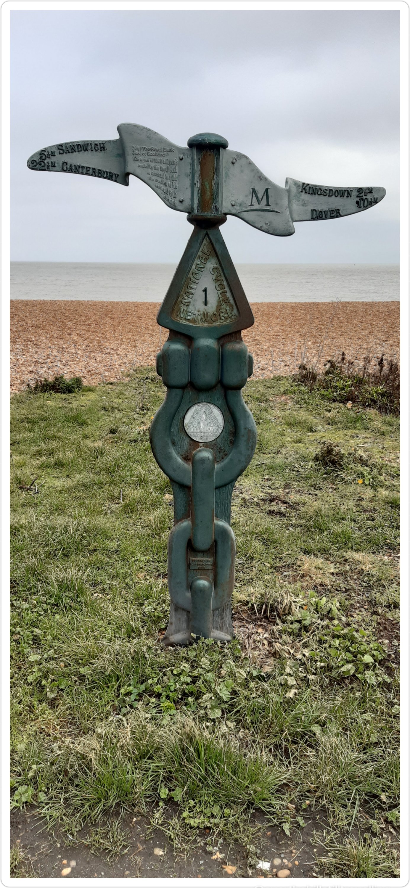
I love these cycle path signs….tempted to follow them one day 🚴♀️🚴♀️🚴♀️
Dover 10.5 miles
Dover 9 miles
I love this little square
And of course, you can’t visit a seaside town and not stop to look at the boats
A pretty fishing boat
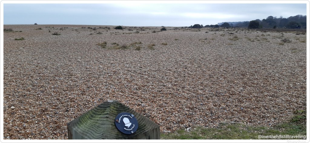
And finally, one of my favourite signs
The Acorn – symbol of the National Trails – England Coastal Path
And today’s walk added another 8kms to my Mt. Everest virtual challenge and takes me to nearly half way through the challenge 🚶🏻♀️🚶🏻♀️🚶🏻♀️👏👏👏
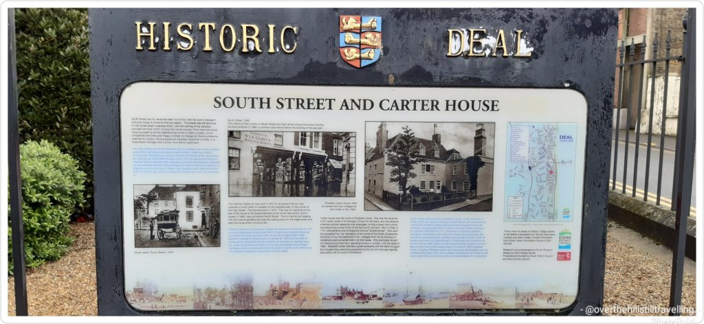
Both Deal and Walmer are mentioned in the 1086 Domesday Book :
Deal was a settlement in Domesday Book, listed as Addelam, in the hundred of Cornilo and the county of Kent. It had a recorded population of 31 households in 1086, putting it in the largest 40% of settlements recorded in Domesday, and is listed under 5 owners in Domesday Book.
Julius Caesar reputedly landed on the beach at Walmer in 55 BC and 54 BC. It is only one possible landing place, proposed judging from the distances given in his account of the landings in his Gallic Wars. However, recent archaeological research and digs have found that he landed at Pegwell Bay. Walmer is probably the settlement Wealemere listed in the Domesday Book.
As I mentioned….loads of history, and both castles are well worth a visit
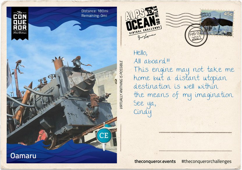
And tah dah!!!! I’m done! I reached Stage 9 and the end of my Alps to Ocean challenge on 2nd February. Hoorah.
Finally here I am 180miles (290km) later, having travelled from the alps of Mount Cook, along multiple lakes, countless connecting rivers, past seven Waitaki Hydro power stations, various mountain ranges, through tussock grasslands, beside electric fences (do not touch) to arrive in the urban town of Oamaru on the shore of the Pacific Ocean.
Oamaru is the largest town in the region and renowned for its Victorian precinct. A commercial streetscape, the Neoclassical architecture is a result of Scottish architect and engineer, Thomas Forrester, who emigrated with his family to NZ in 1861. Arriving in Oamaru to supervise the construction of the Bank of Otago, Forrester stayed on and shortly afterwards was integral to the construction of the Oamaru Harbour. Taking samples from the harbour floor, he deduced that the seabed could be dredged permitting the development of a deep water anchorage. This in turn allowed large ocean-going vessels to safely steer in and out of the harbour. Forrester then changed direction and together with his business partner, over a period of three decades, designed and built the various commercial buildings that still stand today. The precinct bustles with cafes, antiquity shops, bookshops and galleries. Each year it conducts the Victoria Fete, a one day fundraising event with stalls, music, food and period costumes. The funds raised go towards the ongoing care and restoration of the Victorian buildings.
For steampunk enthusiasts, inside one of the Victorian buildings is Steampunk HQ showcasing a collection of quirky items in retro-futuristic sci-fi style whilst outside is a full size train engine spitting fire and billowing smoke. Promoting sustainability and recycling Steampunk HQ collaborates with like-minded artists on projects to continue expanding the collection. Wish you could join me for a steampunk-Victorian era inspired dress-up and for a time feel like we have been transported into an alternative 19th century England.
At the north end of the Victorian precinct is the oldest public garden in NZ. When the town was surveyed in 1858 an area of 34 acres was set aside as a public reserve. Eighteen years later in 1876, the Oamaru Botanical Gardens was opened. Besides the flower beddings, bushes and trees the garden is dotted with various attractions such as the Japanese red bridge, Oriental garden, croquet lawn, sundial, aviary, peacock house, an Italian marble fountain and the Wonderland Statue made by the famous Scottish sculptor Thomas J Clapperton which he donated to the children of Oamaru in 1926. Thomas also made the bronze soldier sculpture on the World War 1 Memorial in Oamaru and is famous for his Robert the Bruce sculpture adorning the entrance of Edinburgh Castle, Scotland.
As I stand on the end of the pier and look across the expanse and vastness of the Pacific Ocean, I wonder at its hidden stories, sunken ships and deep trenches. I wonder what Portuguese explorer, Ferdinand Magellan was thinking when in 1521 he sailed across the Strait of Magellan into the Pacific Ocean and was inspired to name it Mar Pacifico which translates as Peaceful Sea. It’s certainly questionable when you consider the heavy swells, the earthquakes, volcanoes and tsunamis that have battered many Pacific islands and sometimes obliterated complete towns. When I consider the depth and perpetual darkness of the Mariana Trench or the Pacific Rim with the highly active Ring of Fire, peaceful is not something that comes to mind but it is intriguing and fascinating.
This has been such a fascinating journey, it is indeed intriguing. I mean snippets like this are just awesome: Mar Pacifico which translates as Peaceful Sea, although I’m not too sure about the earthquakes et al.
Albeit a virtual journey, it’s made more exciting with the postcards and the information you receive as you reach each stage, and how much I’d love to see that train!! I’ve learned more about New Zealand than I ever knew, as well as from my previous challenges: Mt. Fuji in Japan, The Great Ocean Road in Australia, Ring of Kerry in Ireland etc They’ve all been so interesting.
So far I’ve completed 9 challenges which includes the Conquer 2020 challenge which was a sum total of all my challenges and more in 2020. My favourite so far has been Hadrian’s Wall and I never did get to blog about it…I only thought about sharing these challenges on my blog while I was doing Mt. Fuji because it was so fascinating. I’ll try to blog about the others, but I’ll stick with the shorter ones otherwise it gets too tedious for everyone….anyway, The Ring Road in Iceland is 1,332kms long and I imagine has lots of postcards LOL and the St Francis Way is 503 kms…so likewise.
But I’m starting the Mt. Everest challenge next, and then the Giza Pyramids challenge after I’ve done The Cabot Trail in Canada, so I’ll share that at the time. Of course I may just change my mind and blog about The Cabot Trail too 😉 And here is my certificate. Seriously, within seconds of updating the app, the final postcard and certificate land in my mailbox. I’m going to make books from all of them for each walk….will be fun to look back on one day when I’m older, and infirm and unable to walk far….if I live that long LOL
You have received a new postcard! 🙌 its ridiculous how excited I get when I post a day’s mileage to my app and within seconds I hear the ping of a new email 😃😃 I reached Stage 8 on 28th January, and
It’s with mounting excitement that I realise I’m nearing the end of my virtual journey on the Alps to Ocean route in New Zealand. I started off the challenge on 30th December 2020, and except for a few days along the Kent coast, the majority of my walking has been in the countryside of Throwley, near Faversham – still in Kent.
I’ve been hard put to get my kms in because I only get a 2 hour break each day and some days due to weather I’ve not been able to walk at all. I set my initial goal at 5 weeks but was hoping to complete the challenge in 4 weeks. However, that plan was scuppered when the booking was extended for 3 weeks. 🤔🤔🤔 Nonetheless, I’m not complaining, I’ve enjoyed my stay in Throwley and with another 10 days to go till I leave (as of the 28th), I’m hoping to finish the Alps to Ocean challenge and start on the Giza Pyramids…meanwhile
Stage 8
The small farming-town of Duntroon is home to around 120 residents. It’s main economy is largely sheep farming and crop growing such as wheat and barley.
The town was bestowed its name by one of a handful of Robert Campbells that emigrated from the United Kingdom to Australia and New Zealand. It took quite a bit of unravelling and genealogical construction to discover which of the four generations of Robert Campbells was the relevant one associated with Duntroon. It seems that the name Robert was greatly favoured in the family.
The first Robert (#1) was a grand-uncle from Scotland who was the first merchant in the 1788 British colony New South Wales (Australia) and later a politician. Having built a private wharf at the time he is now referred to as “Campbell of the Wharf”. He had a son named Robert but his brother, John, also had a son named Robert (#2).
This nephew, Robert (#2), arrived in Sydney in 1806 and by 1818 he was the Director and afterwards the President of the first formal bank in Sydney, the Bank of NSW, today known as Westpac. Having also built himself a mercantile business on Bligh Street, Sydney, he became known as “Campbell of Bligh Street”. This Robert, unsurprisingly had a son also called Robert (#3), who was born in Sydney but chose to return to England and became a Member of Parliament from which he was unfortunately unseated threes month later. To distinguish him from previous Roberts’ he was given the appellation “Robert Campbell Tertius” meaning the third.
Finally the relevant Robert (#4), son of Robert Campbell Tertius, who was born in England in 1843, travelled to New Zealand early 1860s to either buy or lease land on behalf of the family. Robert became a successful sheep farmer, property owner and later politician. Together with his father, he owned a sheep station in the Waitaki District upon which they built a small town they named, Duntroon, a Scottish name possibly as homage to their ancestry and their ties to Clan Campbell of Argyll, Scotland.
Robert’s (#4) wife, Emma, bequeathed £6,000 to the parochial district with instructions to build a church for the benefits of Church of England members. The result was St Martin’s Anglican Church in a 14th century Gothic style, built out of limestone quarried in a nearby region. The side church door bears the Clan Campbell coat of arms. Sadly both Robert and Emma died childless and within a few months of each other.
By 1875 much of the acquired Campbell lands became plagued by rabbits that were imported in the 1830s and released for sport. Unable to curtail their rapid reproduction rate, by the early 1880s the pastures were depleted and hillsides eroded. This in turn produced lower quality wool thereby affecting the prices of wool. In the end, the devastation wrought in the region forced many sheep station owners into bankruptcy and the Campbell’s businesses in NZ were eventually wound up and ceased operating by 1920.
Just off the main highway is the Vanished World Heritage Centre, a fossil and geology museum that includes the fossils of two species of extinct genus of large penguins from around 27-28MYA. Known as Archaeospheniscus, the species is about the size of an Emperor Penguin. There was a third species, albeit a smaller one, in this genus that was discovered in Antarctica. These three species are the only ones currently existent in this genus.
Having left Duntroon, I’ve parted ways from Waitaki River which has been my companion since the Waitaki Dam and moved in a south-east zig-zag direction until I stopped at the Rakis Railway Tunnel, an old disused railway line. During the 1880s depression era the construction of the railway provided much needed unemployment relief. The 11mi (19km) line was in use from 1887 to 1930. Today the tunnel is only 330ft (100m) long and although it can be explored, a torch is needed because halfway in the tunnel curves cutting out all source of natural light.
Today will be by far my longest route of this entire journey, hence writing this letter on one of my rest stops. I look forward to rolling into my final destination, Oamaru.
Interesting information provided…..and therein lies the foolishness of history. You can’t just import alien species into a country for whatever reason and expect it to have a happy outcome. If you read history, you’ll discover that there were dozens of similarly stupid and foolish mistakes made by the invaders (of the people kind, not the animal or plant kind) of these islands as well as in Australia and various other countries around the world; the British Empire!! Geez. Well I have to admit that I have no sympathy for the unfortunate Campbells, shooting rabbits for sport – how cruel…and talk about a lack of imagination. With the huge variety of names on offer, could they not come up with something a little different…I mean I like the name Robert on the whole, but surely a little variety wouldn’t have gone amiss?
I do like the Elephant Rocks though and the Vanished World Heritage Centre, sounds like an awesome place to visit.
Anyway…. I’m rapidly reaching the end of my Alps to Ocean NZ challenge!! I always feel a little sad really when they reach the last few miles…..they become friends eventually LOL Okay, okay, don’t say it…I know, it’s daft.
Didn’t take any photos of the area this day because, seriously I have so many already, but I did spot that gorgeous iris hiding under a hedge and the snowdrops are in bloom. So pretty..I love this time of year when the first snowdrops appear…
And because I didn’t faff around too much taking photos, I managed to clock up 11.44kms in 2.5 hours 👏👏👏😁


You must be logged in to post a comment.