I’m reblogging this because it’s an absolutely fascinating article. Castor oil!! Who knew!! Its funny how we take some things for granted without any thought as to where it came from. My Mother used to give us castor oil when we were kids. If we complained of feeling ‘sick’ and didn’t want to go to school, out came the castor oil. It was so vile that invariably we suddenly ‘recovered’ enough to go to school after all 🤣🤣🤣 But tobacco?? 5million deaths worldwide…..actively sold to people around the world, and we lockdown for Covid-19?? Bizarre.
1. Castor Bean, Ricinus communis With oversized, tropical-looking leaves and bizarre seed pods, castor bean is an exotic addition to the ornamental garden. The only member of the genus, Ricinus communis is in the Spurge Family (Euphorbiaceae). The word ricinus is Latin for “tick”, used for this plant name because of the superficial resemblance of the seeds to a particular […]
There’s so much to see and do in Lewes that I’m quite kept on my feet.
Today I set out on my 2nd attempt to find the river pathway and although I wasn’t successful, I believe I’m getting closer 🤣🤣🤣 Saw this on my walkabout
Egrets Way….
I initially followed the instructions from a local but I’m afraid it led me to a great big green field and a gate and although I can see from mapmywalk that I was close to the river, it wasn’t quite where I should have been.
However, I did go off at a tangent on the way back and discovered more of Lewes.
I walked along streets and lanes as yet untrodden by myself, and passed a couple of old favourites
And an old water pump
9.64 kms all told and slowly I’m reducing my 2020 Conqueror challenge deficit. 731.8kms to go by 31.12.2020 🤪🤪🤪
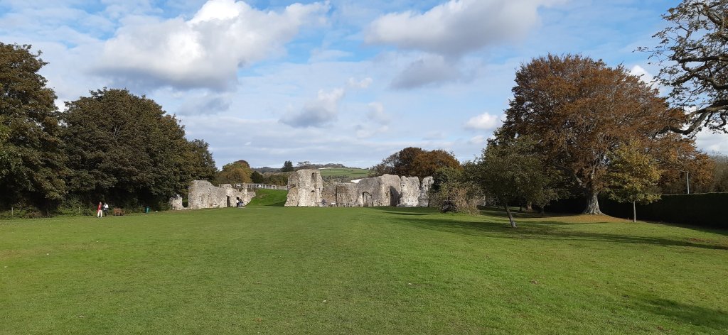
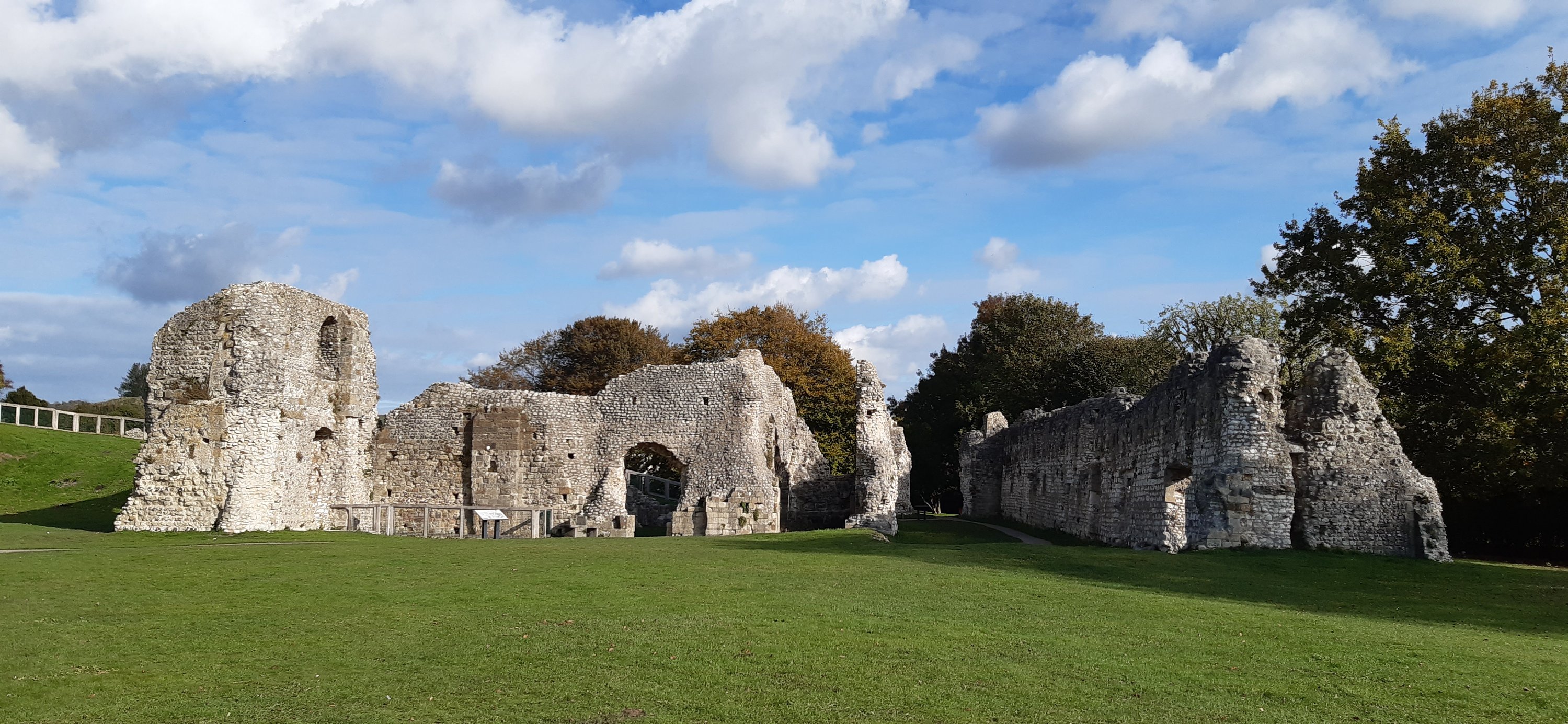
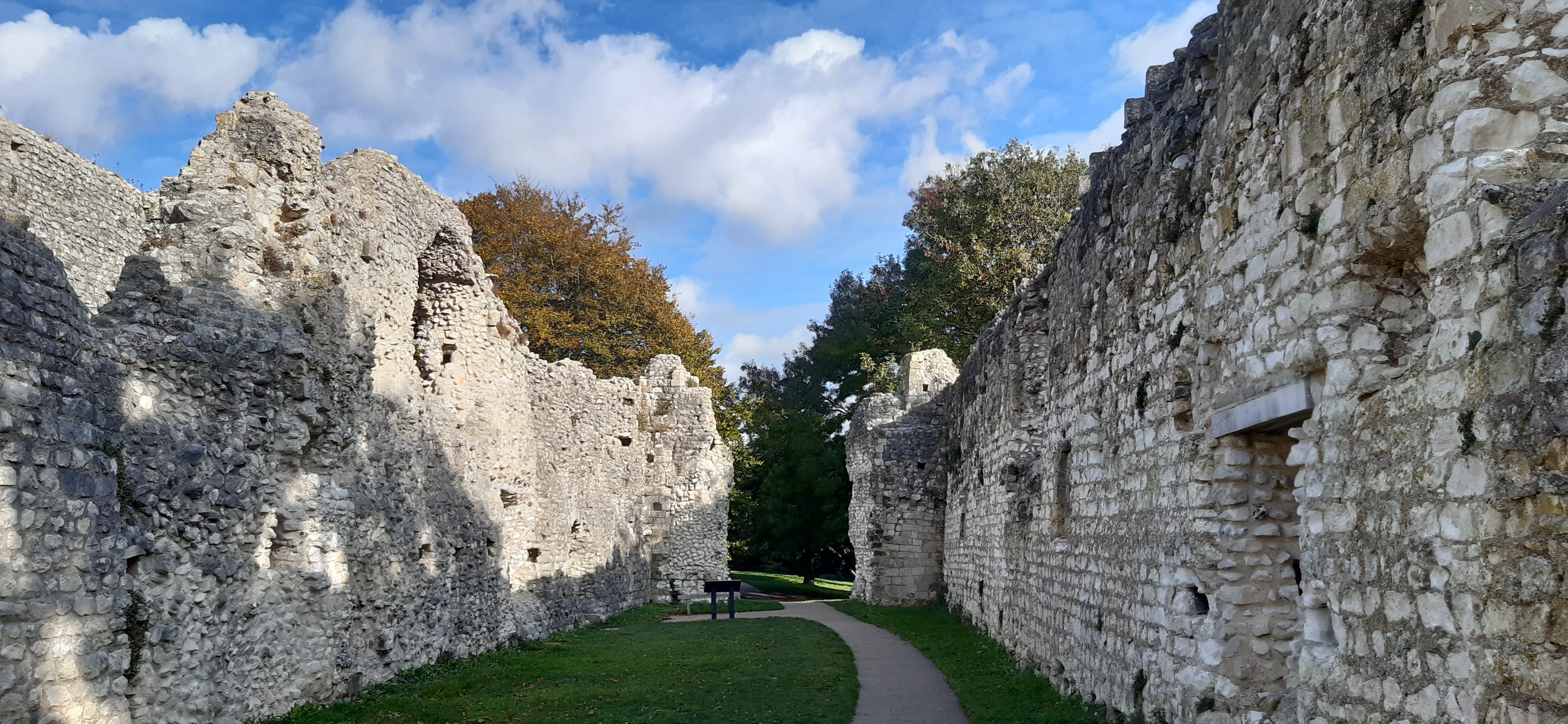
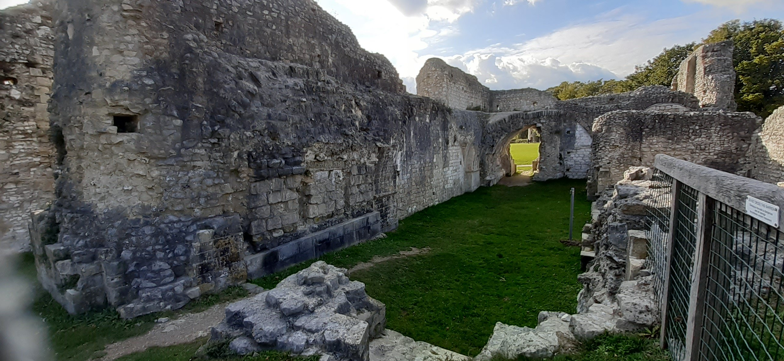
Fantastic discovery today. I set off during my break, determined to find the river path. Instead I found Lewes Priory….or should I say, the ruins.
Lewes Priory
Like 99% of all the abbeys, monasteries, and priories in the country, Lewes Priory also fell foul of Henry VIII’s foul temper!!
Seriously, if I could go back in time, I’d go back to the mid-16th century and give him another whack on the head, maybe knock some sense into the man.
Imagine if he hadn’t destroyed all these amazing buildings, what magnificence we would see today.
But sadly we have to be satisfied with exploring the ruins and trying to imagine what they must have been like. But at least there are some remains to be seen. So little respect was shown for the historical value of the priory that the modern railway was run right over the chapter house. Listed as a Grade 1 building, it seems we have a little more regard for important places these days (although HS2 puts the lie to that 🤨🤨)
In the 11th century, monks traveled from Cluny in France to establish the first Cluniac priory in England. The Priory survived for 450 years until the Dissolution of the Monasteries in 1537.
A number of interpretive boards give you an idea of what the Priory would have looked like and show snippets of how the monks lived and worked. A herb garden has been recreated, replicating the gardens worked by the monks.
The garden
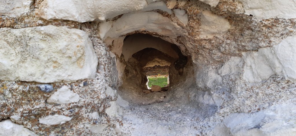
Its fascinating to see how thick the walls were built.
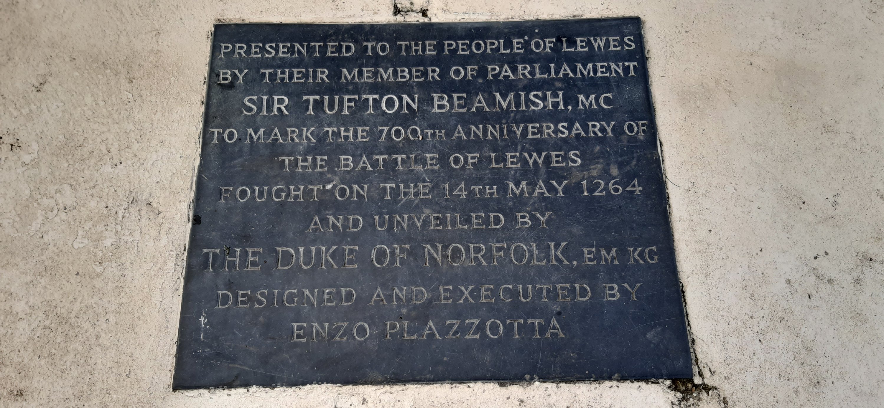
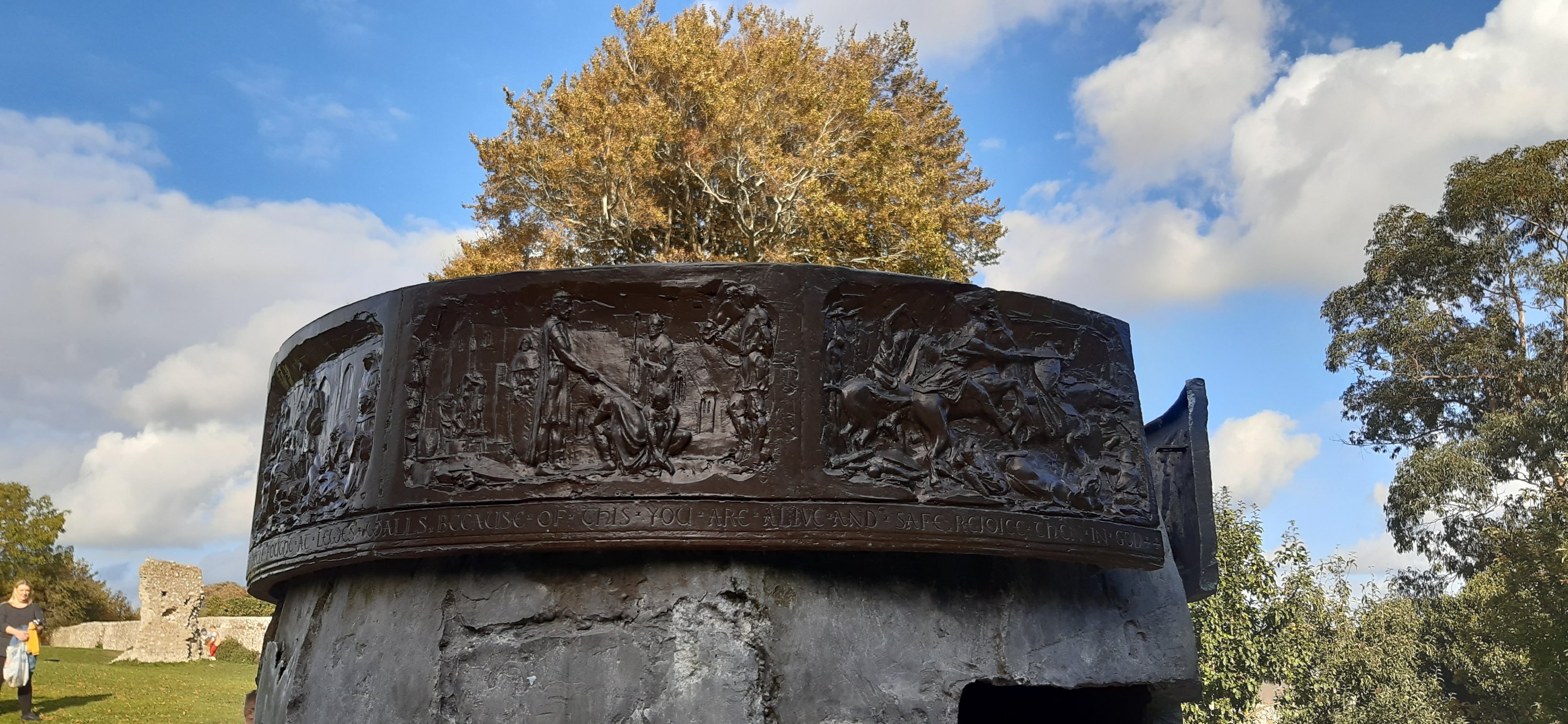
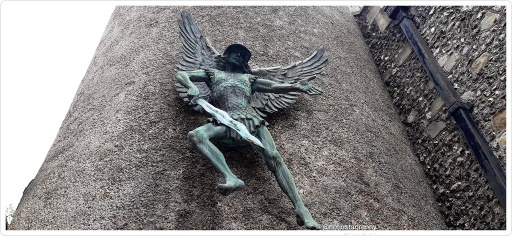
The Helmet Sculpture by Enzo Plazzotta, erected in 1964 to commemorate the 700th anniversary of the Battle of Lewes in 1264, is absolutely stunning.
And in case you were wondering….. Cluny is a commune in the eastern French department of Saône-et-Loire, in the region of Bourgogne-Franche-Comté. It is 20 km northwest of Mâcon. The town grew up around the Benedictine Abbey of Cluny, founded by Duke William I of Aquitaine in 910. Ref wikipedia
Lewes Priory is a must visit if you’re in the area or perhaps walking the South Downs Way ….take a small diversion and visit the town, there’s so much to see.
As mentioned in a previous post, on Monday I took myself on a walk to complete the ‘twittens’ of Lewes, after which I followed the High Street across the River Ouse to explore the other side of town.
To my absolute delight I found a wee church dedicated to St Thomas a’ Becket. Having just completed The Pilgrim’s Way a few weeks ago, this was wonderful little surprise.
St Thomas a Becket Church, Lewes
Of course I had to do some research and this is what I found ❤❤ Thomas a Becket actually visited Lewes at some stage!!! Oh my gosh just WOW!
St Thomas a Becket Church, Lewes
St Thomas a Becket at Cliffe is a parish church in Lewes, encompassing the parish of All Saints. Becket was apparently a benefactor and frequent visitor to the nearby Collegiate Church of St Michael the Archangel, just a short walk away, which I visited just a few days ago. Totally weird to think that Thomas a Becket actually walked through the streets of Lewes. I never really associate him with more than Canterbury Cathedral, but of course he must have travelled to any number of cities and towns in England.
Collegiate Church of St Michael the Archangel, Lewes
Cliffe church, originally a chapel of ease of the college of Malling, was built, either…. so it is said, by the direct order of Archbishop Thomas Becket, to whose martyrdom it is dedicated. But it is also suggested that its building was financed by one of Becket’s murderers as a penance for committing an act of sacrilege, or by someone who witnessed the dastardly act but did nothing to prevent it.
St Michael the Archangel
So 3 options exist…I wonder which it is. If you’re interested in learning a wee bit more about the church, here’s a link https://st-thomas-lewes.org.uk/history/
Super awesome to discover Thomas Becket’s connection with Lewes, and completely unexpected.
Now, I really must get on with updating my pilgrimage, completing the 2nd half of the Pilgrim’s Way from Oxted to Canterbury.
It has however been so exciting to explore Lewes and discover her secrets, and I still have a castle and a priory to visit, as well as the north side of town. Oh and let’s not forget the walks I’d still like to do.
Hoorah!! I did it! I finished walking the Inca Trail; virtually 😃🚶🏻♀️🚶🏻♀️
Hoorah!
My walk today; 10.38kms took me over the finish line by .08km and challenge #4 is complete. As always the postcard that popped into my mailbox is gorgeous and really makes me want to walk the trail for real. But its quite a long way away, so I shall settle for having walked it virtually.
Machu Picchu
Voted as one of the New 7 Wonders of the World and listed on the UNESCO World Heritage Site in 1983, Machu Picchu is a 15th century Inca citadel steeped in mystery and myth. Thought to have been built on the request of the incumbent Emperor Pachacuti as a royal estate, Machu Picchu is an engineering marvel. Built without mortar, the stones are cut so precisely, they fit perfectly together. Sitting atop two fault lines, during earthquakes the stones knock against each other and then fall back into place.
The rise and fall of the Inca Empire lasted a mere 130 years. Following the Spanish invasion of the Inca Empire in early 16th century, Machu Picchu was abandoned with the Spanish unlikely to have ever seen it. Left to the elements the citadel was grown over by vegetation and forgotten over the centuries until 1911 when Hiram Bingham III of Yale University, visited the site as part of an expedition in search of another city. Returning the following year, Bingham spent 4 months with local labour to clear the vegetation and the next 3 years excavating and studying discovered artifacts.
From here the final descent into Aguas Calientes is on a hair-raising 9km zig-zag mountain road called Hiram Bingham Hwy. Barely wide enough to fit two cars and lacking guardrails, it is an unsealed road and a rough ride that is not for the faint of heart nor for those who are prone to vertigo.
Once you arrive in Aguas Calientes, book yourself into a thermal bath to rest and recover your weary body. Take a walk through the local craft market before settling in for dinner. Try the Peruvian national drink, the Pisco Sour, whilst indulging in the spicy and bold flavours of Peruvian cuisine.
Fantastic!! 👏👏👏🚶🏻♀️🚶🏻♀️
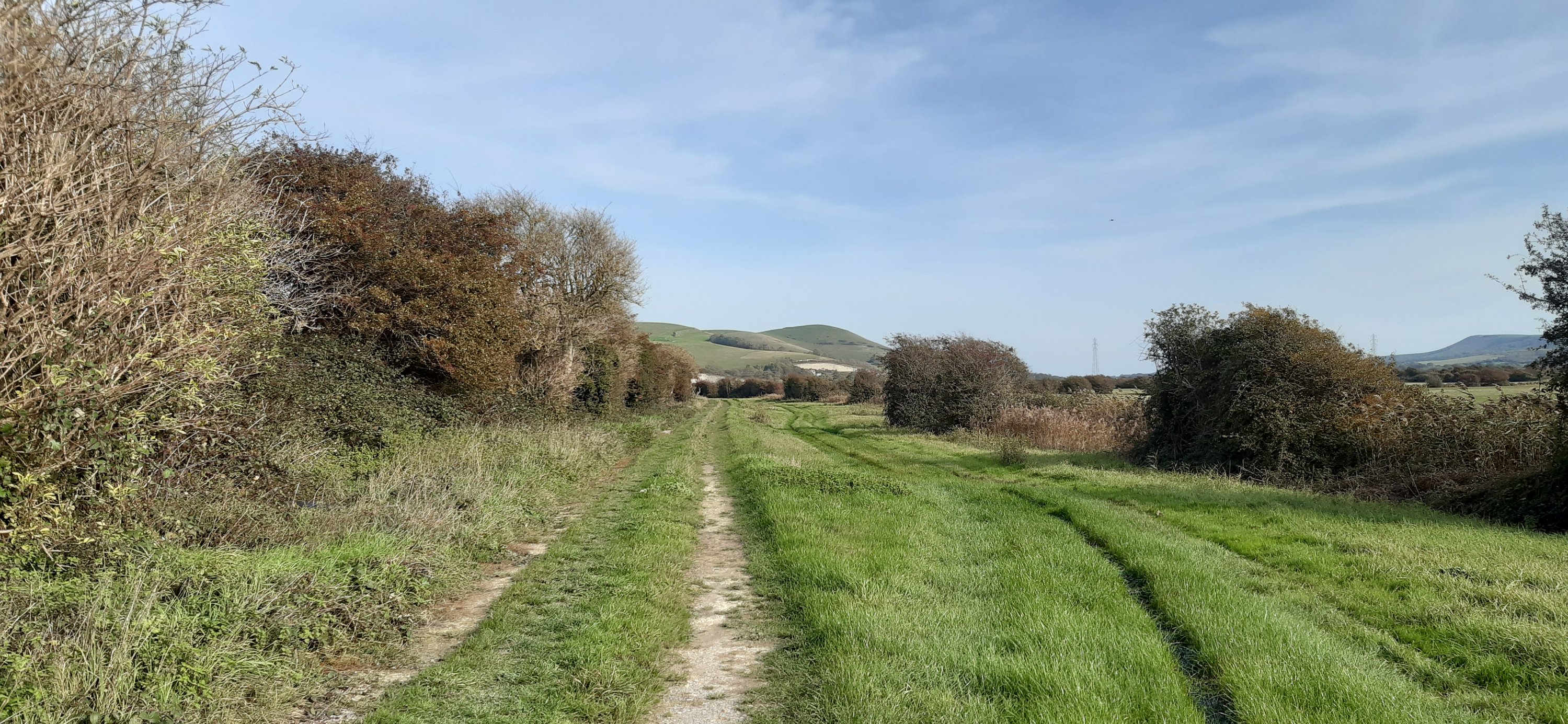
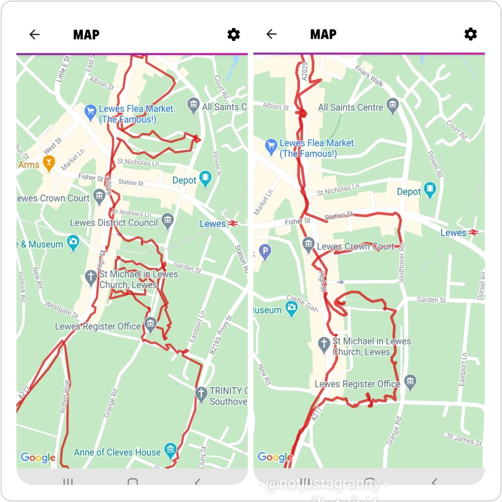
My ‘real’ walk was a little more mundane, but no less satisfying. I had a plan, hmmm??🤪🤪 to follow the river from Lewes to Newhaven. It looks easy enough on Google maps and I spent a few hours last night researching possible routes. But none of them were really clear so today I decided to scout the route as far as possible, and see how far I could get.
Not very far as it turned out 😂😂
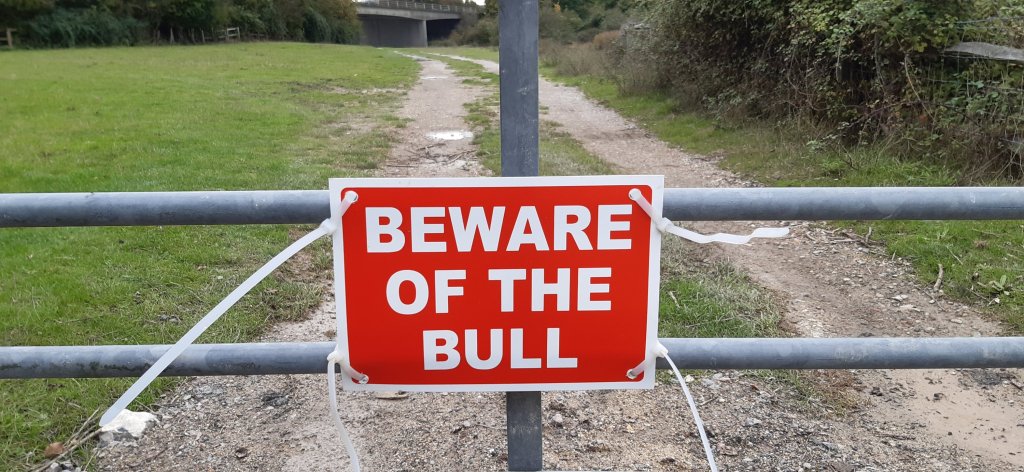
At 2.74kms I faced a wee challenge, a very locked gate and the possibility of unwanted company.
I debated climbing over the gate, but after consideration thought it would be rude and didn’t fancy getting halfway across the field only to find said 🐂 behind me!!
So instead, I retraced my steps and returned to town.
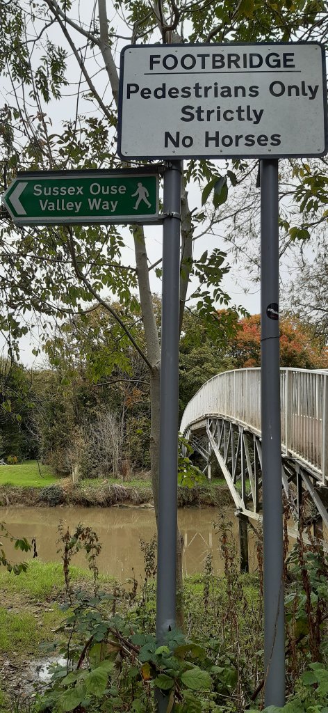
I then decided to follow the river upstream, since downstream wasn’t quite working out. Much better route.
Very pretty, lots of green and a fab path. I crossed over the river via a pedestrian bridge and found myself on the Sussex Ouse Valley Way, and a very walkable path.
The views of the river and valley are just perfect and its well away from any traffic, except for the occasional cyclist.
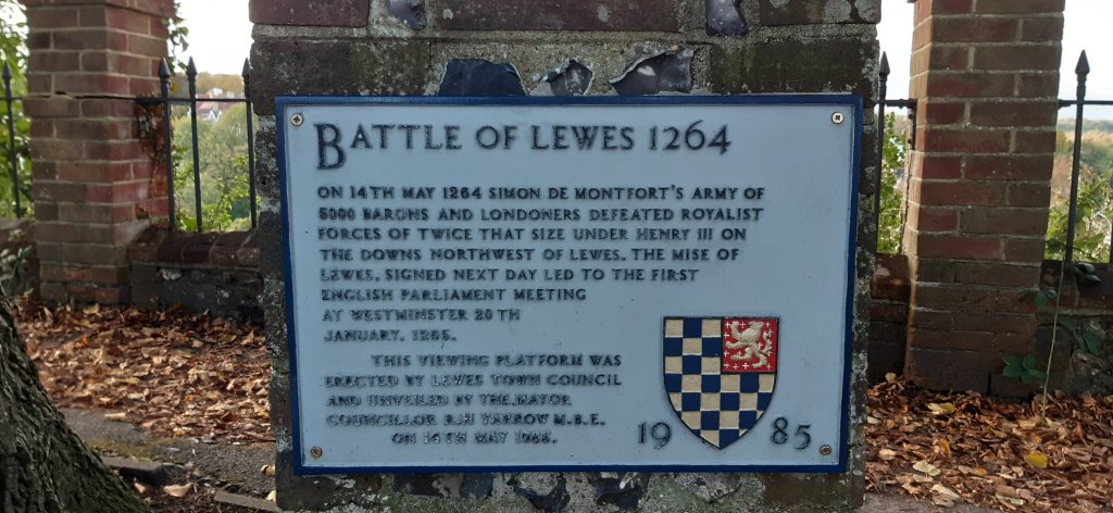
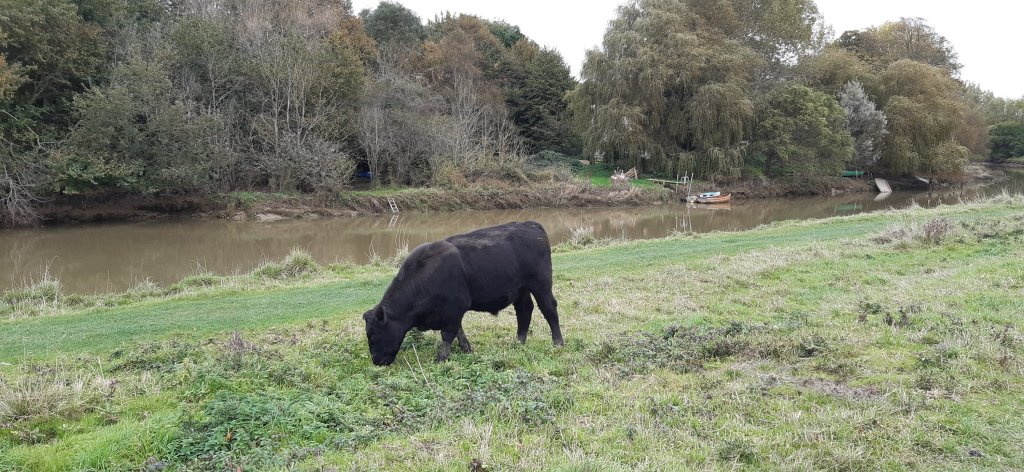
I walked for quite a distance – I could see the Offam church spire peeping up between the trees, the same forests where the Battle of Lewes was fought in 1264
and here I encountered a whole herd of cattle. I walked on some way but in the distance I could see a cow bellowing loudly and having a hissy fit, so before she got the whole bunch worked up, I retreated…as Henry III should really have considered…
This fellow wasn’t one bit interested
Once back over the river, I did a bit of a dogleg and discovered a disused railway line….heading enticingly off into the distance. Not very far according to a local lady, just 1km. So I shall head back that way next week and walk it.
Then with just 3kms to go I headed back to work and after going around the block twice LOL I finally reached 10.38kms and my break was over. But I reached my goal and completed the Inca Trail.
I do so love walking and could really just keep going….
Scenes from the walk Looks a bit like a bow and arrow…
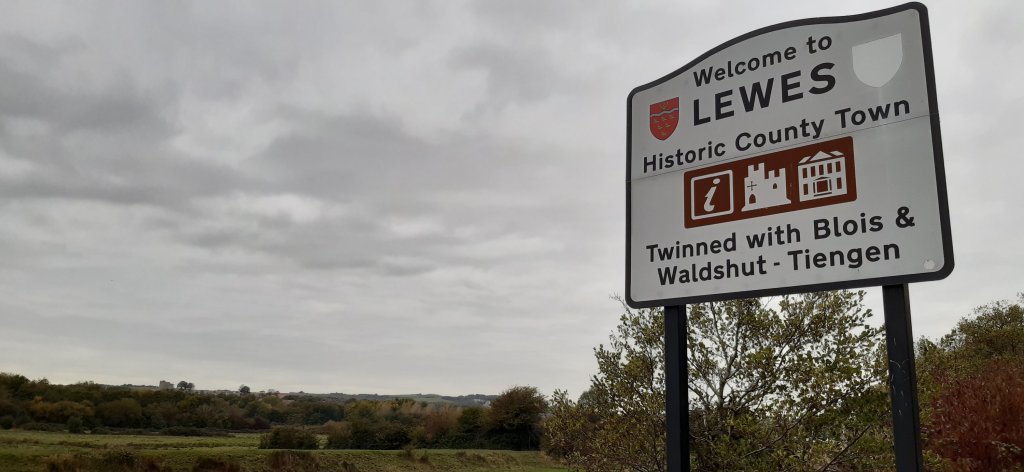
I recently arrived in Lewes for my next assignment (the benefit of working as a Carer is that although I’m away from home a lot, I get to visit some amazing places.
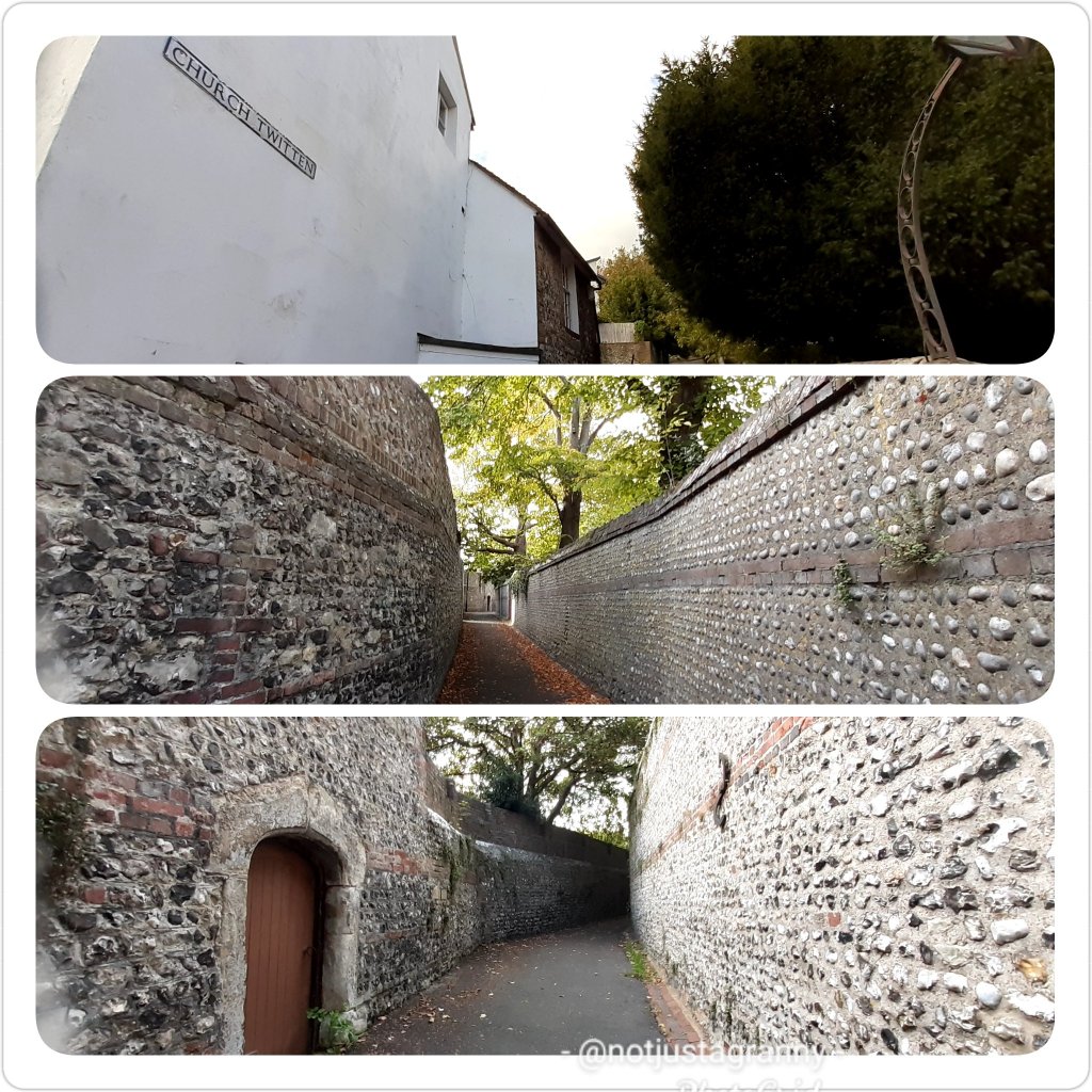
The day after I arrived I set out to explore and noticed that some of the lanes were named ‘twitten’ like Church Twitten for example. So i visited wikipedia and did some research – A distinctive feature of the centre of Lewes is the network of alleyways or ‘twittens’ which run north–south on either side of the High Street and date back to Anglo-Saxon times. According to the Dictionary of the Sussex dialect and collection of provincialisms in use in the county of Sussex published in Lewes in 1875 “Twitten is a narrow path between two walls or hedges, especially on hills. For example, small passageways leading between two buildings to courtyards, streets, or open areas behind”. Some twittens (e.g. Broomans Lane, Church Twitten, Green Lane, Paine’s Twitten) remain flint-wall-lined pedestrian thoroughfares, others (e.g. Watergate Lane, St Andrew’s Lane and renamed Station Street (formerly St Mary’s Lane) are now narrow usually one-way roads. The most notable of all Lewes’ twittens is Keere Street. A weekly Sunday morning run up and down all the twittens on the south side of the High Street – the so-called Twitten Run – has operated in the town since November 2015.
Hmmmm….tell me more. I love a good challenge and of course I’m currently following the Inca Trail virtual challenge so I did some planning and on Sunday during my break I decided to walk all the ‘twittens’ – I managed to walk along most of them and on Monday I walked the rest.
Along the way I discovered amazing places and hidden gardens. The twittens all run downhill, so there was a lot of downhill and up hill walking to be done LOL
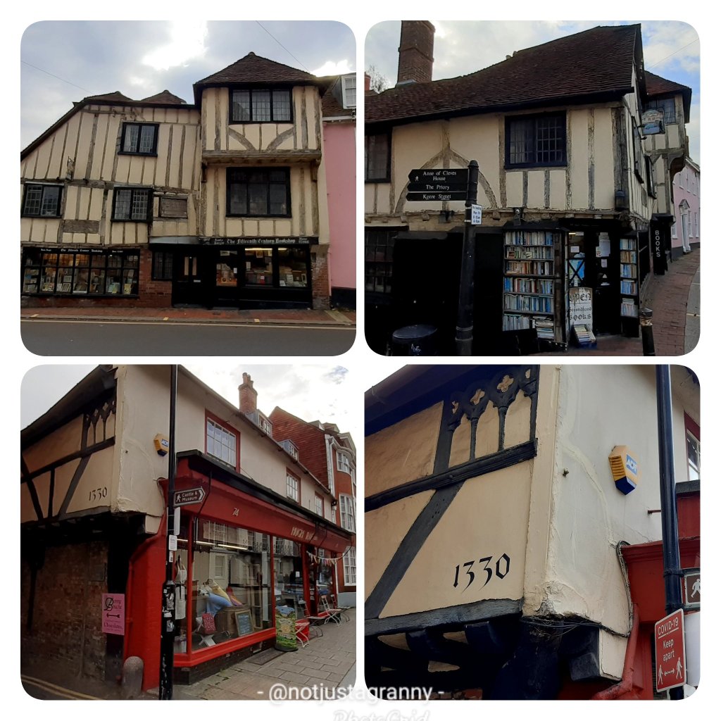
First I walked along Rotten Row past the old Toll House from when the town was gated and near to where the Westgate was originally located – it’s no longer in existence unfortunately. I walked right to the end past the Lewes cemetery and left into Bell Lane and then left into Southover High Street where I passed the Anne of Cleves house, sadly closed atm due to Covid-19. There a number of wonderful old houses/buildings dating from the 14th and 15th centuries.
Still following Southover High Street I walked passed Southover Gardens and up to Bull Lane (off Southover Road).
From there I walked up Paines Twitten to the High Street then right and down St Swithun’s Terrace. Left again into Bull Lane and left into Green Lane up to Stewards Inn Lane where I turned right and then right again into St Martin’s Lane. Downhill all the way to Southover Road and then left into Watergate Lane uphill to the High Street. A lengthy walk later I turned downhill into Walwer’s Land and left into Friars Walk and after a quick visit to the church; All Saints,
I turned left into Church Twitten and uphill once again to the High Street. Last turn right into Broomans Lane back to Friars Walk and then back to the High Street and home…5.55 kms.
The following day I walked a total of 4kms to finish walking all the lanes and twittens.
Lewes is seriously cool and I wish I had planned to stay overnight for recreational purposes 😃 Maybe next time.
Meanwhile I have plenty more exploring to do, there are some fantastic dedicated walks and circular walks in the area. And so much history to discover….
As I’ve mentioned before, in my job I get to travel and work all over the country. I consider myself very lucky to be able to do this, especially during these challenging times when a lot of people are struggling with lockdown and unable to get out much.
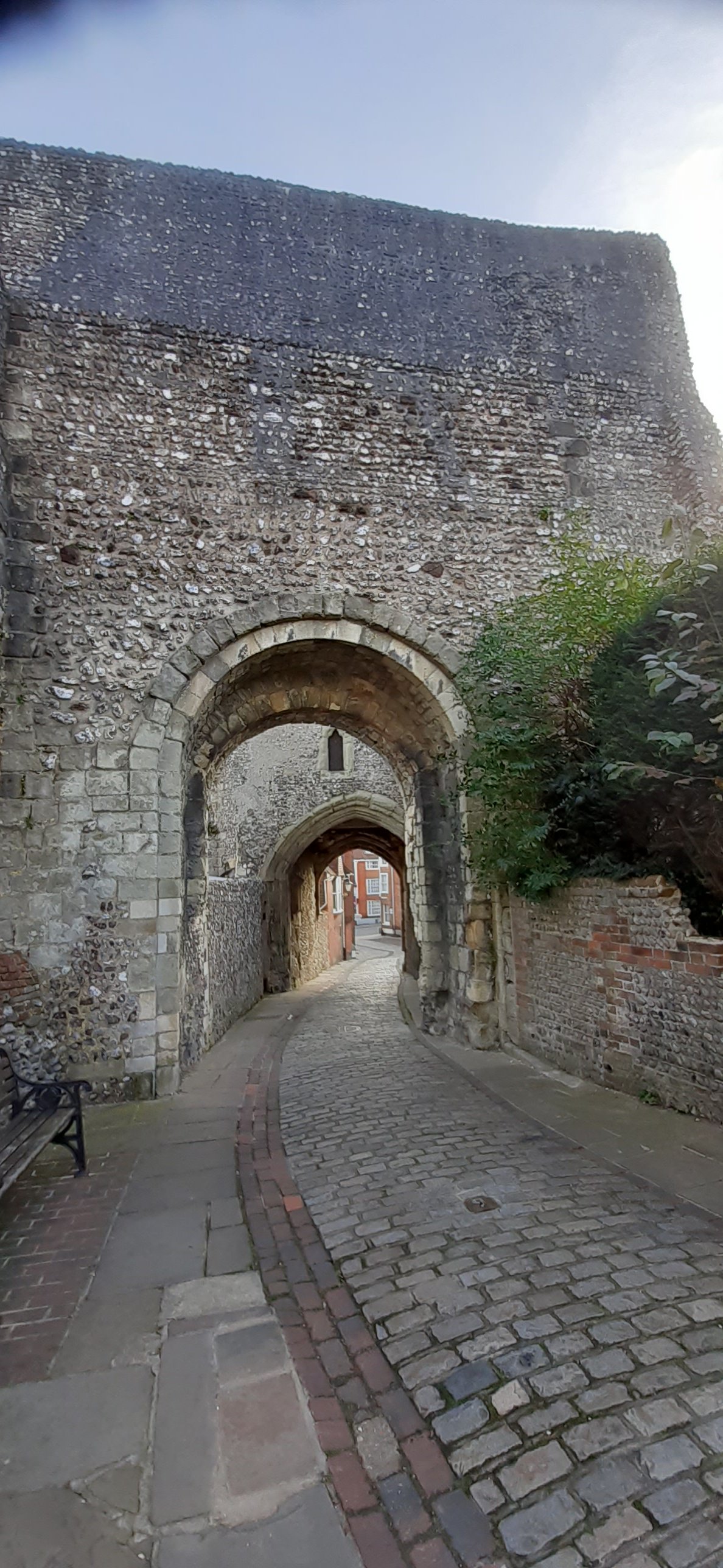
Travel is my opiate and I love discovering new places, especially if the history of said place includes a mention in the 1086 Domesday Book, or boasts a castle, or a Roman wall (anything Roman in fact makes me happy), or even just an awesome history. And Lewes has just about all of the above.
The narrow cobbled lanes, the quirky high street, and to my delight I spotted 2 very old buildings as we drove up the high street to my next assignment.
I had a choice of 2 bedrooms, either the 1st level, or the 2nd…I chose the 2nd level despite all the stairs because the views across the countryside are absolutely stunning, the hills are enticingly close – and I have a wonderful view of the sunrise…when it’s not raining.
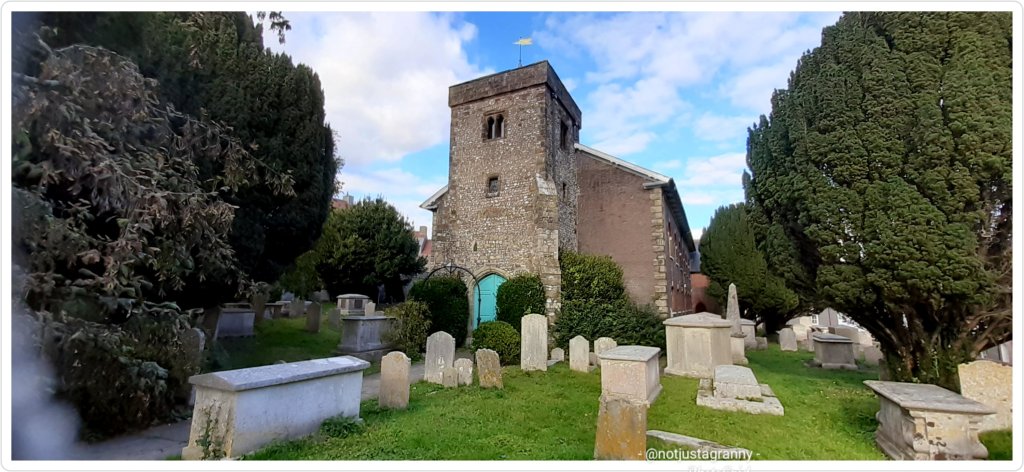
On Saturday during my break I immediately set off to explore and walking along the High Street I first walked through the churchyard of St Anne’s Church. I noticed a row of 12 cast-iron memorials, early19th century; all for the same family, and of 10 children, 9 died before the age of 4 years…the youngest was 4 months old. Only 1 child survived till the age of 38. Heartbreaking. I’ve put a link to the church’s history because its absolutely fascinating.
Next I passed the Old Toll House which stood at the west gate into the city. The gate no longer exists and the toll house on Rotten Row is now a private residence.
I popped in at St Michael’s Church on the High Street but had to admire the interior from behind a thick glass ceiling to floor window. Closed due to Covid-19. Urgh. This damn virus. I love these ancient churches and always welcome an opportunity to visit.
Meandering along I suddenly discovered the castle 😃😃😃 I’d been so enchanted by the old medieval buildings, I’d missed the even older castle. But there it was. Unfortunately I couldn’t enter that day because I had neither mask nor money, but they’re open every Saturday, so next it shall be.
I explored the lanes and back paths on the north side of town and admired the views across the downs. Oh how much I’d love to walk those downs….soon. The autumn colours are just stunning.
I discovered quite by accident the old windmill apparently once owned by Virginia Woolf…awesome. The views of the castle from the back streets on the north side were stunning and I mentally kicked myself for not having money and a mask, the views from the castle ramparts must be stunning!!
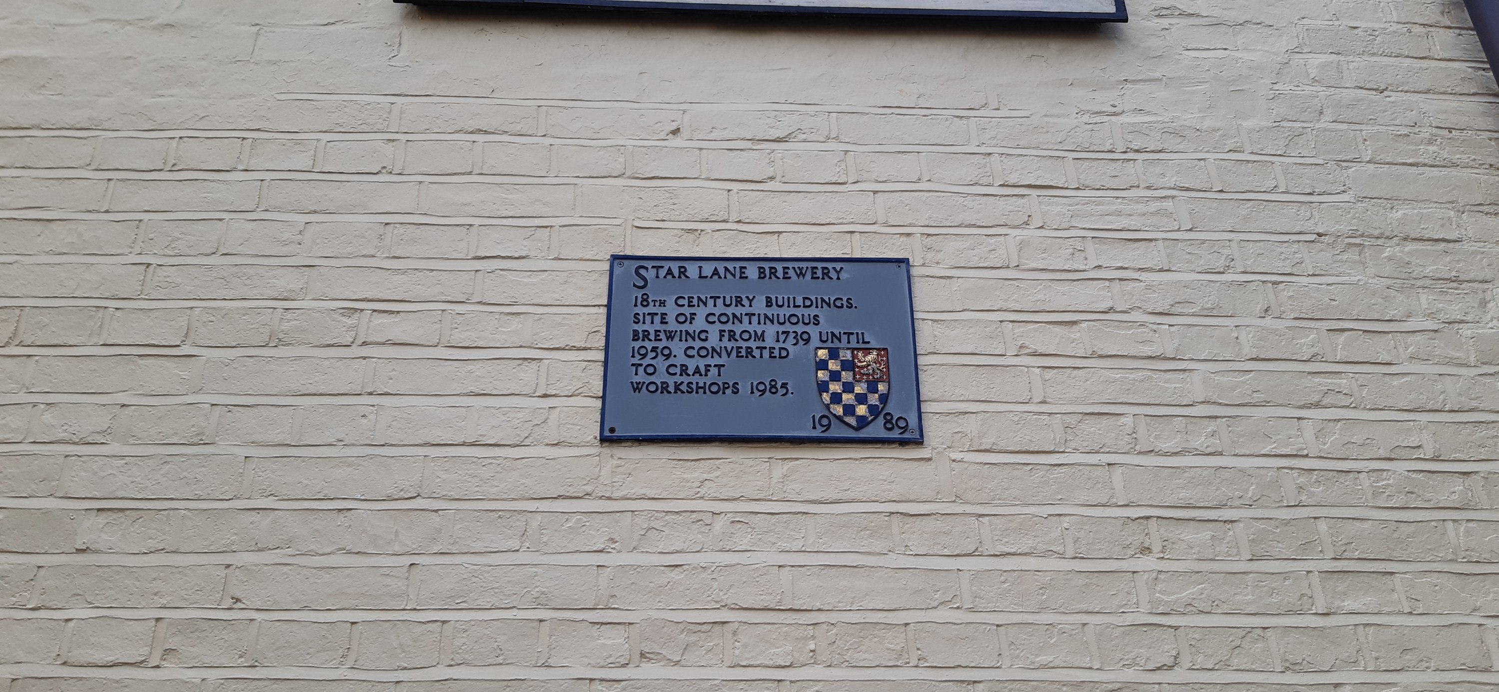
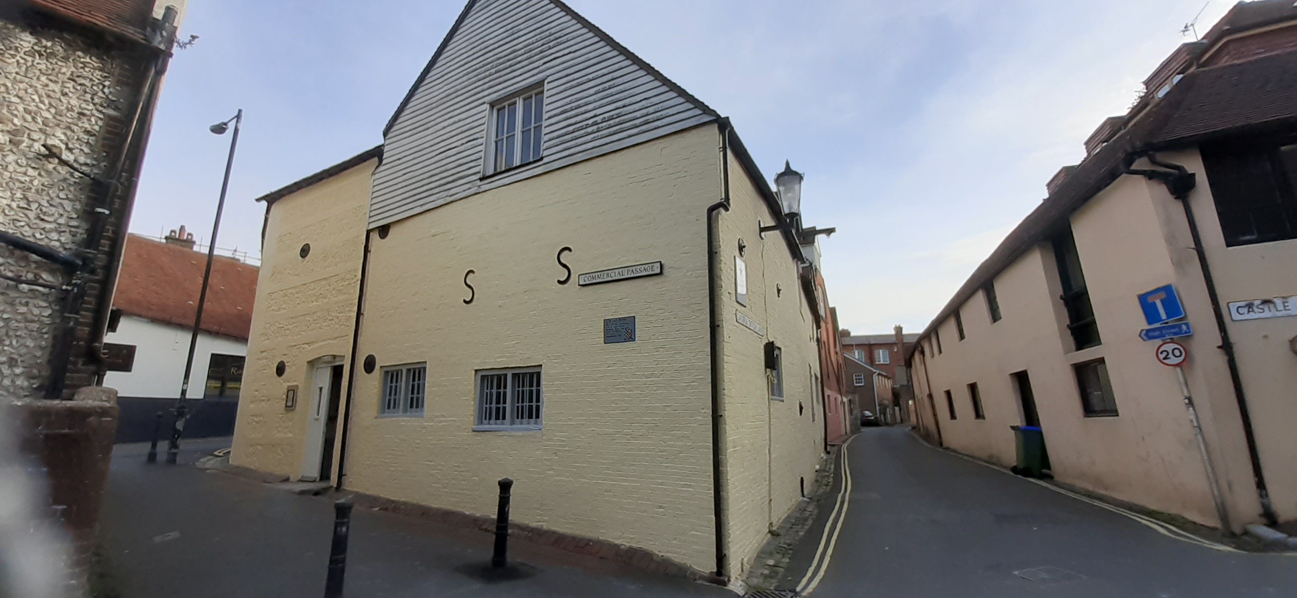
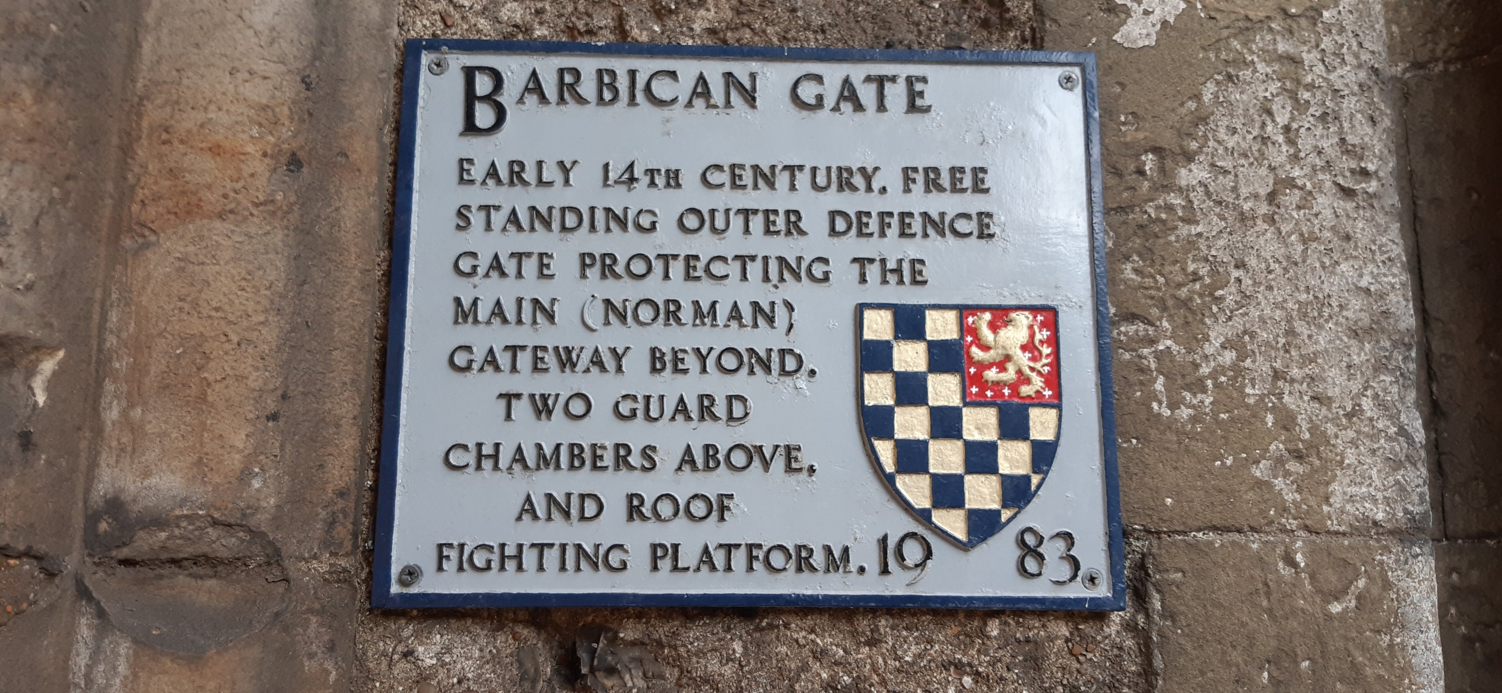
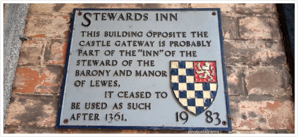
From there I meandered along the High Street admiring the old buildings and taking dozens of photos (nothing new there then 🤭🤭) History plaques are attached to many of the buildings and give a fascinating glimpse into the towns varied past.
History plaques
I spotted a banner with a compilation of photos from the famous annual Lewes Bonfire Night event. I immediately kicked myself again 🤪🤪….this was something I’d wanted to witness ever since I read about it some years ago, but forgotten…on further investigation I learned that sadly, it has been cancelled for 2020 due to Covid-19, but I’ll make a note for future. From wikipedia: Lewes Bonfire or Bonfire, for short, describes a set of celebrations held in the town of Lewes, Sussex that constitute the United Kingdom’s largest and most famous Bonfire Night festivities, with Lewes being called the bonfire capital of the world. If you Google Lewes Bonfire videos, you’ll find some extraordinary footage.
I walked past the old Flea Market which looked very interesting and could have done with a bit of a wander, but again….no mask. You’d think that by now I’d be used to wearing a mask and remember to take it with me on my meanderings, but no….🤪🤪
The WW1 & 2 memorial looked absolutely beautiful
I made a brief sortie along the upper parallel lanes of the south side, but didn’t feel like walking back UP the very steep lanes if I went down…tomorrow is another day LOL
On my return to my work location, I hopped on to wikipedia and did some research. To my delight I discovered that Lewes is mentioned in the 1086 Domesday Book which brings the total number I’ve visited to 147!!! 😃😃
Reading further my curiosity about the ‘twittens’ was piqued. I’d noticed that some of the South side lanes had names like Church Twitten and I was intrigued. I’d never come across the word ‘twitten’ before, and I’ve visited dozens of old villages in the last 12 years.
According to wikipedia: the network of alleyways or ‘twittens’ which run north–south on either side of the High Street date back to Anglo-Saxon times. According to the Dictionary of the Sussex dialect and collection of provincialisms in use in the county of Sussex published in Lewes in 1875. “Twitten is a narrow path between two walls or hedges, especially on hills”. Well, how about that. Fascinating, and I learn something new every day. ☺ jm just amazed I’ve never come across the word before….surely twittens are not unique to Lewes!?
Lewes looks absolutely charming and I’m looking forward to exploring more thoroughly over the next 3 weeks.
A few snippets of history:
The Saxons invaded East Sussex in the 5th century.
Founded in the 6th C, the name Lewes is probably derived from a Saxon word, ‘hluews’ which meant slopes or hills.
In the late 9th C King Alfred made a network of fortified settlements across his kingdom called burhs.
Saxon Lewes was also a busy little town with weekly markets. In the 10th C it had 2 mints; it was a place of some importance.
At the time of the Norman Conquest in 1066 Lewes probably had less than 2,000 inhabitants.
The Normans built a castle to guard Lewes and founded the priory (small abbey) of St Pancras in Lewes.
Lewes was listed as a settlement in the 1086 Domesday Book with a recorded population of 127 households, putting it in the largest 20% of recorded settlements, and is listed under 2 owners.
St. Anne’s is a Grade One Listed Norman Church, on the medieval Pilgrim’s route from Winchester to Canterbury and built with pilgrim money.
In 1148 King Stephen granted Lewes a charter.
In the 13th century Franciscan friars arrived in Lewes.
In 1264 the Battle of Lewes was fought between King Henry III and some rebellious barons led by Simon de Montfort.
In 1537 Henry VIII dissolved the Priory. In 1540 Henry gave Anne of Cleves House to his wife after their divorce – however Anne never lived there.
The plague struck in 1538.
During the reign of Catholic Queen Mary (1553-1558), 17 Protestants from Sussex were martyred in Lewes.
The famous radical, Tom Paine, lived in Lewes from 1768 to 1774.
I was reading through some Instagram posts this morning and a post by one of my favourite ‘grammers’ caught my eye.
She commented about having encountered some ‘yompers’ on a trail she was recently walking, and how their speeding ahead made her feel a bit inadequate. I’d not heard the expression ‘yompers’ before, but I do remember seeing them whizzing by when I walked the Camino in 2017.
Their faces set, backs straight, poles thumping the ground, they stride steadfastly ahead, looking neither left nor right, they whizz ahead at speed…. I often wondered why!!
They miss the scenery, they miss the little treasures along the wayside, they never (from what I saw) engaged with the locals, or visited a church to sit down and absorb the tranquillity- mostly they entered a church to get their passport stamped, and out again…once more to yomp ahead. I really would love to know why…..??
Is it a matter of finishing the route as quickly as possible, do they have a limited time to walk, is it about clocking up miles the fastest, getting to the albergues first to secure a bed, or perhaps they just add each route completed to a check list? Done this, done that, no t-shirt.
I’m classified as a ‘slow stroller’ – although my family would disagree 😂😂🤪
Walking for me is about the freedom of being outdoors, about the scenery, the little discoveries I make along the tide line or on top of cliffs, about visiting the important landmarks enroute, and often going completely ‘off-piste’ to visit some place I’d seen on Google while planning my trip. I don’t always reach my destination (unless I have a confirmed booking) but oh my, how much I enjoy just looking, enjoying and absorbing while walking.
The yompers can yomp, I prefer to absorb my environment and actually remember what I’ve experienced…. and of course to take as many photos as possible 😉
Which is also why I mostly walk alone; going solo I can stop whenever, wherever I like, take photos every 5 seconds, have a snooze under a tree in a graveyard, or a shady stand of trees….sit in a pub and enjoy a beer, or cup of tea….I’m not holding anyone up, and I’m not annoying anyone because I keep stopping…
And having said that, I really must get myself a good mobile charger. The battery on my latest Samsung (2018) is crap and despite closing all background apps, the battery fizzles out after 6-8 hours. I stress about taking photos because the camera uses a lot of power, so invariably I spend money in pubs along the way while I boost my phone. Its tiresome.
I’ve tested one or two models, but they don’t do the job and I end up returning them to the store…. something small and powerful would be useful please Universe 🌌🌠☺
Meanwhile, I’ll keep strolling….and the yompers can yomp!!
I have lots of crazy ideas, and this is definitely one of them..
I don’t always put my crazy ideas into action, but after consulting with myself while walking from Sandwich to Deal, we – me, myself and I 😉 decided it would be a fun (crazy) idea to walk the full England Coast Path.
Since I had already started, and had walked from Ramsgate to Sandwich, and was now walking from Sandwich to what turned out to be Walmer and not Dover, we figured it would be a fun goal to have….
And so the decision was made to walk the full English coast…or should I say “attempt to walk” 🤣🤣🤣
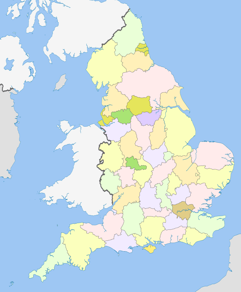
The map is from wikipedia
When I look at the map above, I know for sure it’s a crazy idea, but other people have walked the entire UK coast, so why not….
I started doing some research and discovered that England has 12,429 km or 7,723 miles of coastline excluding islands.
Which means that if I walk an average of 20 kms a day it will take me 621.45 days to walk the entire coast. But if I walk 3 days per month it’ll take 207 days….or something like that. I’m pretty sure my calculations are skewed 🤪🤪🤪 and it will actually take me 5 years or so to complete. 😂😂
But so far I’ve walked from Ramsgate to Dover over 3 days, so let’s see.
The challenge has begun!! Which brings me to the virtual challenges I’ve signed up for…
I’m currently walking the Inca trail and since its only 42kms I’m sure I’ll be done within the next 10 days. From there I’m going to do the Ring of Kerry, although to be honest, I’d much rather be walking that route in real time….its eminently possible that once we’re free to travel again, I may just walk the route in Ireland…why not.
This is not an affiliate link and I don’t make any money from people signing up, but you get a 10% discount on any walks you sign up for and I think a 10% discount as well….which is a moot point really since I’ve already signed up for all the walks I want to do 😃😃😃
Here’s to walking…..my favourite hobby despite the pain 😉🚶🏻♀️🚶🏻♀️🚶🏻♀️
At the beginning of the year, just after lockdown, I decided to join the Conqueror Virtual Challenge and signed up to walk Hadrian’s Wall – 145km (England). As you progress they send you postcards with interesting information about the walk.
the medal
Mostly so I could keep up my enthusiasm for walking, having a goal during lockdown was so helpful. In the meantime I’ve decided to walk the real Hadrian’s Wall – now scheduled that for 2021.
I’ve subsequently done the Camino de Santiago challenge – 772km (Spain). I did this while working; using my kms walked while on duty and various other walks at the various places I worked in. My medal is in the post.
The English Channel challenge – 34km (I finished that with short walks over 4 days) much as I would have loved to swim the distance for this challenge, I have NO plans to actually swim the English Channel….end of! LOL
the medal is in the post 🙂 It’s stunning
All of the above counts towards my goal of #walk1000miles2020 and despite deciding to not sign up for any other challenges, guess what….LOL I’m signing up for the pack of 5 which includes a choice of some awesome virtual walks: Great Ocean Road – 240km (Australia), Inca Trail – 42km (Peru), Ring of Kerry – 200km (Ireland), The Cabot Trail – 298km (Canada), and The Ring Road – 1332km (Iceland). I’m also going to buy the 2020 challenge coz the medal is awesome. I’m sure I can finish the 4 shorter distances this year and I’ll do the Icelandic Ring Road in 2021. The medals are so beautiful and I love the motivation the app gives me as I watch my progress.
I’m also keen to do the John O’Groats to Lands End virtual challenge and will save that for 2021 as well.
If you’d like to join me on the Conqueror Virtual Challenges click here for the link There’s a terrific little app that you can update as you go and it shows your progress on a map, you can join as part of a team or just go it alone. For every 20% of the challenge you complete the organisers plant a tree (I love that idea) and at the end of the challenge you get a fantastic, quality medal. It’s good fun and you learn about the different places as you reach each milestone.


You must be logged in to post a comment.